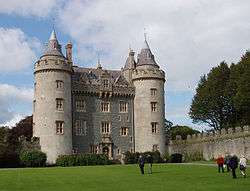
Killyleagh
_-_geograph.org.uk_-_458764.jpg)
_-_geograph.org.uk_-_296250.jpg)

Killyleagh (/kɪliˈleɪ/; from Irish: Cill Ó Laoch, meaning "church of the descendants of Laoch")[1][2] is a village and civil parish in County Down, Northern Ireland. It is on the A22 road from Downpatrick, on the western side of Strangford Lough. It had a population of 2,483 people in the 2001 Census. It is best known for its 12th century Killyleagh Castle. Killyleagh lies within the Down District Council area and the Strangford Constituency area.
Demography
Killyleagh is classified as an intermediate settlement by the NI Statistics and Research Agency (NISRA) (i.e. with population between 2000 and 4000 people). On Census day (29 April 2001) there were 2,483 people living in Killyleagh. Of these:
- 22.5% were aged under 16 years and 20.3% were aged 60 and over
- 49.5% of the population were male and 50.5% were female
- 37.8% were from a Catholic background and 60.4% were from a Protestant background
- 4.4% of people aged 16–75 were unemployed.
For more details see: NI Neighbourhood Information Service
Places of interest
- Killyleagh Castle is a riot of turrets and battlements rising like a fairytale vision above Killyleagh as this amazing Loire-style chateau completely dominates the small village. It is a private family home, claimed to be the oldest inhabited castle in Ireland. It has been the home of the Hamilton family since the 17th century Plantation of Ulster and acquired its fairy-tale silhouette in the 1850s when the turrets were added, but it is mostly the same castle that the second Earl of Clanbrassil rebuilt in 1666. The castle hosts occasional concerts. In the past performers have included Van Morrison, Arlo Guthrie, Jackson Browne, Glen Hansard and Bap Kennedy.
- Delamont Country Park is just outside Killyleagh on the road to Downpatrick.
Sport
People
- It was the birthplace of Hans Sloane. He began collecting plants and birds eggs on the shores of Strangford Lough and his accumulation grew into a priceless collection that formed the nucleus of the British Museum. He was also personal physician to King George II.
- Reverend Edward Hincks, a renowned Assyriologist and Egyptologist, was appointed Church of Ireland rector of Killyleagh in 1825, an office he was to hold for the remaining forty-one years of his life.
- Killyleagh's adjacent townland, Moymore, was the birthplace of William Carr, who emigrated to Pittsburgh USA, became an entrepreneur and left his fortune "to his Irish relatives."[3]
- Dr Henry Cooke was the minister of 1st Presbyterian Church, who went on to become Moderator of the General Assembly and a leading exponent of orthodox Presbyterianism in Belfast in the mid 19th century. His statue in Belfast, standing outside the Royal Belfast Academical Institution, is known as "The Black Man".
- Killyleagh is the home town of David Healy, the retired Northern Ireland football player. Healy is Northern Ireland's record goalscorer by a considerable distance, with 36 goals. The second highest total is 13 goals. He also holds the record for most goals scored in a European Championship Qualifying Phase, with 13 goals during the country's failed bid to reach Euro 2008. Healy's former Bury teammate Trevor Carson is also from Killyleagh.
- The present Duke of York, HRH The Prince Andrew, also has the title Baron Killyleagh.
- Robert Lowry (1824–1904), born in Killyleagh, emigrated to the USA and became a judge and U.S. Representative from Indiana.
- Thomas L. Young (1832-1888), born in Killyleagh, served as Governor of Ohio from 1877 to 1878.
Twin town
Killyleagh is twinned with Cleveland, North Carolina, USA.
Civil parish of Killyleagh
The civil parish is mainly in the barony of Dufferin, with one townland in the barony of Castlereagh Upper. It also contains the village of Killyleagh.[4]
Townlands
The civil parish contains the following townlands:[4]
- Ardigoa
- Ballyalgan
- Ballygoskin
- Ballymacarron
- Ballymacromwell
- Ballytrim
- Ballywillin
- Clay
- Cluntagh
- Commons
- Corbally
- Corporation
- Derryboy
- Dodd's Island
- Dunnyneill Islands
- Gibb's Island
- Island Taggart
- Killinchy in the Woods
- Kirkland and Toy
- Lisinaw
- Moymore
- Mullagh
- Pawle Island
- Rathcunningham
- Ringdufferin
- Simmy Island
- Toy and Kirkland
- Tullykin
- Tullymacnous
- Tullyveery
See also
| Wikimedia Commons has media related to Killyleagh. |
References
- ↑ PlaceNames NI
- ↑ Placenames Database of Ireland
- ↑ https://news.google.com/newspapers?nid=1144&dat=19120612&id=pcAaAAAAIBAJ&sjid=_UgEAAAAIBAJ&pg=1946,3071579&hl=en. Missing or empty
|title=(help) - 1 2 "Killyleagh". IreAtlas Townlands Database. Retrieved 17 May 2015.
External links
Coordinates: 54°24′N 5°39′W / 54.40°N 5.65°W
