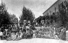
Kerem Avraham

Kerem Avraham (lit. Avraham's Vineyard) is a neighbourhood near Geula in central Jerusalem, Israel, founded in 1855.[1] It is bounded by Malkhei Yisrael Street, Yechezkel Street, Tzefanya Street, and the Schneller Compound.
History

Kerem Avraham was established by James Finn, British Consul in Ottoman Jerusalem, and his wife Elizabeth Anne Finn. Finn was a devout Christian, who belonged to the London Society for Promoting Christianity Amongst the Jews, but who did not engage in missionary work during his years in Jerusalem.
In 1853, Finn purchased Karm al-Khalil ("Abraham's Vineyard"), a 10-acre plot of barren land outside the walls of the Old City. There he established "The Industrial Plantation for Employment of Jews in Jerusalem" to train Jews in agriculture and other trades so they could become self-supporting, rather than relying on the halukka welfare distribution.[2][3] The manager was a Christian named Dunn who believed he was a descendant of the tribe of Dan.[4] Finn employed Jewish laborers to build the first house there in 1855 and cisterns for water storage were built.
After Finn's death, a soap-making factory was established by his widow and high quality kosher soap was produced which was sold locally and exported abroad. The soap was made from olive oil fat mixed with alkali, sourced from the ashes of the kali plant which grew in the Jordan valley. The soap production became the most widely known industry which took place at the compound.[5]
Israeli novelist Amos Oz grew up in Kerem Avraham in the 1940s. Most of the residents of Kerem Avraham today are Orthodox.[3]
References
| Wikimedia Commons has media related to Kerem Avraham. |
- ↑ History of Kerem Avraham
- ↑ "Jerusalem Architecture - Periods and Styles, European Christian Buildings Outside the Old City Walls, 1855-1918," David Kroyanker, Keter, 1987 (Hebrew) pp.419-21.
- 1 2 JUF News : Men in black
- ↑ History of Kerem Avraham
- ↑ Palestine: The Rebirth of an Ancient People, 1917, - Page 73.
Coordinates: 31°47′24.06″N 35°13′2.04″E / 31.7900167°N 35.2172333°E
