Kaftoun
| Kaftoun كفتون | |
|---|---|
| City | |
 | |
 Kaftoun Location within Lebanon | |
| Coordinates: 34°16′N 35°46′E / 34.267°N 35.767°ECoordinates: 34°16′N 35°46′E / 34.267°N 35.767°E | |
| Country |
|
| Governorate | North Governorate |
| District | Koura District |
| Time zone | EET (UTC+2) |
| • Summer (DST) | EEST (UTC+3) |
| Dialing code | +961 |
| Website | http://www.kaftoun.com/ |
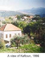
Kaftoun (Arabic: كفتون) is a small Lebanese village located along the north bank of the Walnut River, in the Koura District, North Lebanon. The population of the village is approximately three-hundred, spread around seventy-four houses. They are mostly of Greek Orthodox ancestry.[1] The village is famous for the Moussa-Georges family.[2] The name "Kaftoun" in the ancient Aramaic language means "dug from" or "sculpted from" a cliff and also (Kftuna) could means "the domed". Both roots of the word lead us to believe that the village of Kaftoun was named after the domed Theotokos Monastery[3] which is carved in the red rock cliffs by the banks of the Jaouz River.
Kaftoun has three historic churches:[4] Saint Phocas Church (Mar Foka's[5]), the Church of Saint Sergius and Bacchus (Mar Sarkis[6]) 6th century, and the most famed Theotokos Monastery,[7] which houses a two-sided Byzantine icon[8] from the 11th century.
References
- ↑ "Municipal and ikhtiyariah elections in Northern Lebanon" (PDF). The Monthly. March 2010. p. 23. Retrieved 1 November 2016.
- ↑ Kifraya website
- ↑ Photo Gallery. Kaftoun. Retrieved on October 12, 2011.
- ↑ Kaftoun Churchs. Kaftoun.com (6 November 2004). Retrieved on October 12, 2011.
- ↑ Photo Gallery. Kaftoun. Retrieved on October 12, 2011.
- ↑ Photo Gallery. Kaftoun. Retrieved on October 12, 2011.
- ↑ The Kaftoun Theotokos Monastery - a jewel of spirituality!. Kaftoun.com (30 March 2005). Retrieved on October 12, 2011.
- ↑ Kaftoun's Theotokos. Ortmtlb.org.lb. Retrieved on October 12, 2011.
External links
- http://www.kaftoun.com/
- Kaftoun, Localiban
