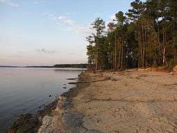
Jordan Lake State Recreation Area
| Jordan Lake State Recreation Area | |
| North Carolina State Park | |
 View from Ebenezer Church shoreline | |
| Named for: B. Everett Jordan | |
| Country | United States |
|---|---|
| State | North Carolina |
| County | Chatham, Wake |
| Elevation | 216 ft (65.8 m) |
| Coordinates | 35°44′13″N 79°1′1″W / 35.73694°N 79.01694°WCoordinates: 35°44′13″N 79°1′1″W / 35.73694°N 79.01694°W |
| Area | 4,558 acres (1,844.6 ha) [1] |
| Animal | Bald eagle |
| Founded | 1982 |
| Management | North Carolina Division of Parks and Recreation |
| - coordinates | 36°13′15″N 79°3′13″W / 36.22083°N 79.05361°W |
|
Location of Jordan Lake Recreation Area | |
| Website: Jordan Lake State Recreation Area | |
Jordan Lake State Recreation Area is a North Carolina state park spanning Chatham County, and Wake County North Carolina in the United States. It comprises 4,558 acres (18.45 km2)[1] of woodlands along the shores of 13,940-acre (56 km2) Jordan Lake.
History
The New Hope River Valley, now home to the corporate world of Research Triangle Park, has been the site of a broad range of cultures for more than 10,000 years. Archaeologists have explored the remains of 450 prehistoric and historic sites in the area and have uncovered many Native American artifacts. The land was settled by Scottish Highlanders in the 1740s, and it saw action in both the Revolutionary and Civil wars.
Following a disastrous hurricane, which struck the Cape Fear River Basin in 1945, Congress directed the U.S. Army Corps of Engineers to undertake a comprehensive study of water resource needs in the area. The project, then known as New Hope Lake, was authorized in 1963 and construction began in 1967. In 1973, the name of the project was changed to B. Everett Jordan Dam and Lake in honor of the former senator from North Carolina.
Jordan Lake Park's 46,768 acres (189 km2) are not only a popular source of recreation, they also provide the water supply for surrounding cities, flood and water quality control, and fish and wildlife conservation.[2]
Recreational use

The Jordan Lake State Recreation Area is divided into several smaller areas: Farrington Point, Crosswinds, White Oak, Poplar Point, Ebenezer Church, New Hope Overlook and Poes ridge along the eastern shoreline and Robeson Creek, Vista Point, Seaforth, Parkers Creek, and the Jordan Lake Educational State Forest along the western shore. Swimming, boating, hiking, fishing, hunting, birdwatching and picnicking are popular activities making up 3 Boat ramps, 1 canoe launch, 2 swim beaches, 2 play grounds, 3 fishing piers (including an ADA accessible one), a marina, and 5 campgrounds. Facilities are managed by North Carolina Division of Parks and Recreation, North Carolina Wildlife Resources Commission, North Carolina Division of Forest Resources, US Army Corps of Engineers, Wake County Parks and Recreation, and a privately managed marina.[3]
Events held at the park include monthly skywatching sessions offered by park rangers, the Morehead Planetarium and Science Center in nearby Chapel Hill, and volunteer amateur astronomers from the Chapel Hill Astronomical and Observing Society at the Ebenezer Church Recreation Area in the park.[4]
See also
References
- 1 2 "Size of the North Carolina State Parks System" (XLS). North Carolina Division of Parks and Recreation. January 1, 2015. Retrieved October 3, 2015.
- ↑ "Jordan Lake State Recreation Area". North Carolina Department of Environment and Natural Resources. Retrieved 2007-03-28.
- "USGS Merry Oaks (NC) Topo Map". TopoQuest. Retrieved 2008-07-05.
- ↑ US Army Corps of Engineers. "B Everett Jordan Dam and Lake". Brochure.
- ↑ "Skywatching Sessions". Morehead Planetarium.