Hurricane Otis (2005)
| Category 2 hurricane (SSHWS/NWS) | |
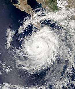
 Hurricane Otis on September 30 | |
| Formed | September 28, 2005 |
|---|---|
| Dissipated | October 3, 2005 |
| Highest winds |
1-minute sustained: 105 mph (165 km/h) |
| Lowest pressure | 970 mbar (hPa); 28.64 inHg |
| Fatalities | None reported |
| Damage | Minimal |
| Areas affected | Western Mexico, Baja California Sur |
| Part of the 2005 Pacific hurricane season | |
Hurricane Otis was a moderate hurricane that threatened the Baja California Peninsula but dissipated before landfall. Otis developed on September 28, 2005, off the western coast of Mexico, from a tropical wave that emerged from the western coast of Africa and traversed the Atlantic Ocean during the preceding several weeks. After attaining tropical storm status on September 29, the storm moved in a generally northwestward direction for most of its duration. It ultimately peaked at Category 2 intensity on the Saffir–Simpson Hurricane Scale before beginning to weaken. The storm degenerated into a tropical depression on October 3 and dissipated fully on October 5, near the coast of Baja California Sur. Preparations for the storm were completed on the Peninsula; tropical cyclone watches and warnings were declared and numerous shelters opened. However, the storm's effects were minimal, and limited to gusty winds with heavy rainfall. No major damage was reported.
Meteorological history

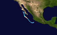
The origins of Hurricane Otis are believed to have been in a tropical wave that emerged from the west coast of Africa on September 9. The wave moved westward across the Atlantic Ocean, spawning Tropical Depression Seventeen on September 17.[1] The southern portion of the wave continued westward, crossing into the eastern Pacific Ocean on September 22. As the wave entered a monsoon-like environment, convection increased on September 23.[2] An associated area of disorganized clouds and thunderstorms persisted off the coast of Mexico for several days, although due to wind shear and its proximity to land, short-term tropical cyclone development—if any—was expected to occur slowly.[3][4] On September 27, it began to show signs of organization; the National Hurricane Center (NHC) remarked upon the potential for a tropical cyclone to develop within the next day.[5] It is estimated that the system became a tropical depression at 0000 UTC on September 28, while located about 140 miles (230 km) to the south of Manzanillo, Mexico.[2]
The depression moved slowly toward the southwest and became better organized,[2] despite a decrease in the coverage of deep convection.[6] By late September 28 the depression was approaching tropical storm status;[7] it turned to the northwest and attained winds of 40 mph (64 km/h) at 0600 UTC on September 29, at which time it was assigned the name Otis.[2] That evening, wind shear relented and conditions became more favorable for the storm's intensification. Convection wrapped almost fully around the center,[8] and early on September 3, Otis was upgraded to a Category 1 hurricane on the Saffir–Simpson Hurricane Scale.[2] Shortly thereafter, a ragged eye feature developed;[9] it quickly became better defined as it entered the scope of weather radar in Cabo San Lucas.[10]
Otis began gradually entering cooler ocean waters, although the National Hurricane Center noted in one of its discussions on the system that the environment was still warm enough to support a stronger storm.[11] The hurricane continued drifting northwestward, and early on October 1 it reached peak intensity at Category 2 status. At the time, maximum sustained winds were at 105 mph (165 km/h) and barometric pressure was recorded at 970 mbar (hPa; 28.64 inHg). Hours later, however, it began to weaken,[2] a trend that continued due to southwesterly wind shear and dry air.[12] The cloud pattern associated with the hurricane deteriorated on October 2, and the center of circulation was separated from the convective activity.[13] Otis weakened to a tropical storm and drifted erratically toward the north-northwest as a result of weak steering currents.[2] Over increasingly cold waters, the cyclone further weakened to a depression on October 3 and consisted of a small swirl of low-level clouds.[2][14] It became a remnant low pressure area the next day. The system abruptly turned southeastward and drifted parallel to the coast of the Baja California Peninsula until dissipating on October 5.[2]
Preparations and impact
On September 30, the first tropical cyclone watches and warnings were issued with the declaration of tropical storm warnings and hurricane watches along portions of the east and west coasts of the Baja California Peninsula. For several days the advisories were adjusted and amended, and on October 1, a hurricane warning was posted for the west coast of Baja California, from Agua Blanca to San Andresito. By October 2, all watches and warnings were discontinued on the east coast of the peninsula, and the remaining advisories were lifted the next day.[2] High winds and heavy rainfall were anticipated.[15]
In advance of the storm, the governor of Baja California Sur, Narciso Agundez, ordered emergency personnel to Comondú, Lorteo, and Mulege. Approximately 700 families fled to shelters in Cabo San Lucas; elsewhere, an additional 200 families evacuated in San Jose del Cabo. Some residents in Miraflores and Santiago also left their homes.[16] Agundez asked soldiers to assist the islands of Magdalena and Margarita in preparing for the storm.[17] Five communities in Mexico, including Cabo San Lucas, declared a state of emergency.[18] Authorities throughout the region opened numerous shelters, and in some locations, police officers went door-to-door asking residents to leave. The port in Cabo San Lucas was closed due to the storm's threat, although the airport remained open.[19]
Although the center of Otis remained offshore, tropical storm-force winds were reported at higher elevations over portions of southern Baja California. At Cabo San Lucas, an automated weather station recorded a wind gust to 63 miles per hour (101 km/h) on September 30, with sustained winds of 49 miles per hour (79 km/h).[2] There, periods of heavy rainfall mixed with fair skies as the storm passed.[20] No damages or fatalities were reported, although some media reports indicated that the storm caused flooding in parts of the southern Baja California peninsula. Offshore, two ships reported tropical-storm-force winds in association with the storm: the Volendam on October 3, and the Star Harmonia on October 1.[2]
See also
- Timeline of the 2005 Pacific hurricane season
- List of Baja California hurricanes
- 2005 Pacific hurricane season
References
- ↑ James L. Franklin (February 9, 2006). "Hurricane Philippe Tropical Cyclone Report" (PDF). National Hurricane Center. Retrieved 2009-02-15.
- 1 2 3 4 5 6 7 8 9 10 11 12 Jack Beven (January 18, 2006). "Hurricane Otis Tropical Cyclone Report" (PDF). National Hurricane Center. Retrieved 2009-02-14.
- ↑ Franklin (September 26, 2005). "September 26 Tropical Weather Outlook". National Hurricane Center. Retrieved 2009-02-15.
- ↑ Stewart (September 27, 2005). "September 27 Tropical Weather Outlook". National Hurricane Center. Retrieved 2009-02-15.
- ↑ Stewart (September 27, 2005). "September 27 Tropical Weather Outlook (2)". National Hurricane Center. Retrieved 2009-02-15.
- ↑ Stewart (September 28, 2005). "Tropical Depression 15-E Discussion Number 3". National Hurricane Center. Retrieved April 15, 2010.
- ↑ Beven (September 28, 2005). "Tropical Depression 15-E Discussion Number 4". National Hurricane Center. Retrieved April 15, 2010.
- ↑ Beven (September 29, 2005). "Tropical Storm Otis Discussion Number 8". National Hurricane Center. Retrieved April 15, 2010.
- ↑ Avila (September 30, 2005). "Hurricane Otis Discussion Number 9". National Hurricane Center. Retrieved April 15, 2010.
- ↑ Stewart (September 30, 2005). "Hurricane Otis Discussion Number 11". National Hurricane Center. Retrieved April 15, 2010.
- ↑ Beven (September 30, 2005). "Hurricane Otis Discussion Number 12". National Hurricane Center. Retrieved April 15, 2010.
- ↑ Roberts/Knabb (October 2, 2005). "Hurricane Otis Discussion Number 17". National Hurricane Center. Retrieved April 15, 2010.
- ↑ Avila (October 2, 2005). "Hurricane Otis Discussion Number 18". National Hurricane Center. Retrieved April 15, 2010.
- ↑ Avila (October 3, 2005). "Hurricane Otis Discussion Number 23". National Hurricane Center. Retrieved April 15, 2010.
- ↑ Ignacio Martinez (September 30, 2005). "Hurricane Otis continues to strength as it moves toward Baja peninsula". Associated Press. Retrieved 2009-02-14.
- ↑ Associated Pres (October 2, 2005). "A crawling Hurricane Otis batters Mexico coast". The Boston Globe. Retrieved 2009-02-14.
- ↑ Staff Writer (October 2, 2005). "Families Flee as Hurricane Otis Brushes Mexico". Los Angeles Times. Retrieved 2009-02-14.
- ↑ Associated Press (October 2, 2005). "Hurricane Bears Down On Mexico". The Washington Post. Retrieved 2009-02-14.
- ↑ Ignacio Martinez (September 30, 2005). "Hurricane Otis strengthens, moves toward Baja peninsula". The Union Tribune. Retrieved 2009-02-14.
- ↑ Associated Press (October 2, 2005). "Otis weakens to tropical storm". USA Today. Retrieved 2009-02-14.
