Hoffman Island
|
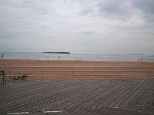
Hoffman Island on left and Swinburne Island on the right as seen from South Beach-Franklin Delano Roosevelt Boardwalk at South Beach, Staten Island | |
| Geography | |
|---|---|
| Location | Lower New York Bay |
| Coordinates | 40°34′44″N 74°03′13″W / 40.578873°N 74.053688°W |
| Area | 11 acres (4.5 ha) |
| Administration | |
|
United States | |
| State |
|
| City | New York City |
| Borough | Staten Island |
Hoffman Island is one of two small artificial islands in the Lower New York Bay, off South Beach, Staten Island.[1] A smaller island, known as Swinburne Island, lies immediately to the south.[2] Created from Orchard Shoals by the addition of landfill in 1872 and named for former New York City mayor (1866–1868), and then-current New York Governor (1869–1871) John Thompson Hoffman, Hoffman Island covers 11 acres (4.45 hectares), while Swinburne Island's area is about 4 acres (16,000 m²).[3][4] The latter island, also of artificial origin, was originally called Dix Island, but was renamed in honor of Dr. John Swinburne, a noted military surgeon during the Civil War.[5]
In the early 1900s, the islands were used as a quarantine station, housing immigrants found to have been carrying contagious diseases when they landed at Ellis Island.[1]
World War II
At the start of World War II the United States Merchant Marine used both islands as a training station (which opened in 1938);[3][6] the Quonset huts built during this period still stand on Swinburne Island.
The other major use for the two islands during World War II were as anchorages for Antisubmarine Nets that fenced off New York Bay from the Atlantic Ocean to keep enemy submarines out.[3]
Post–World War II plans
Since World War II, city planners and politicians have floated various proposals for what should be done with the two islands. Robert Moses and Bernard Baruch advocated transforming the islands into a city park, but this plan was soon forgotten. In 1961, all existing buildings on Hoffman Island were razed,[7] and since then, trespassers have been apprehended on the island from time to time. In the 1980s, some Staten Island residents proposed building a large homeless shelter on Hoffman Island or Swinburne Island or both, in response to the city's plans to open new shelters in some of the borough's residential neighborhoods. This plan was never implemented either.
Current use
Today, both Hoffman and Swinburne islands are managed by the National Park Service as part of the Staten Island Unit of Gateway National Recreation Area. They are still off-limits to the general public, to protect the islands' avian residents. Hoffman Island hosts a large number of nesting wading birds, including great egret, snowy egret, black-crowned night heron, and glossy ibis. Double-crested cormorant dominate Swinburne, and great black-backed gulls nest on both islands. Beginning in 2001, harbor seals have been seen wintering around the islands.[2]
See also
References
- 1 2 "Quarantine At New York". Harper's Weekly. September 6, 1879. Retrieved 2008-07-28.
April 23, 1863, what is now known as the General Quarantine Act was passed, defining the quarantine establishment, authorizing its construction, creating the permanent office of Quarantine Commissioner, defining the duties and powers of the Commissioners and Health Officer, and establishing a general system of quarantine for the port. Additional powers were conferred by amendments made to this general act in 1864, 1865, 1866, and 1867, under which two small steamers were purchased; the property at Tompkinsville, Staten Island, known as the Marine Hospital Grounds, was sold; and the artificial islands in the lower bay were undertaken and afterward completed – Swinburne Island in 1860, and Hoffman Island in 1873.
- 1 2 Newman, Andy (March 25, 2006). "Swimmers From the North Delight Scientists and Sightseers". New York Times. Retrieved 2007-08-21.
The inhabitants of Hoffman and Swinburne Islands, man-made piles in Lower New York Bay off Staten Island, have tended to be there not because they particularly want to be, but because they have to. In the 19th century, the islands were a holding area for new immigrants feared to be carrying diseases. Later, they housed soldiers with venereal disease, quarantined parrots and, until the 1940s, merchant marines in training.
- 1 2 3 Kenneth T. Jackson: The Encyclopedia of New York City: The New York Historical Society; Yale University Press; 1995. P. 149.
- ↑ John T. Hoffman was born on January 10, 1828 and he died on March 24, 1888
- ↑ Poole, M. O. (February 28, 1937). "Historic Islands At New York's Front Door.". New York Times. Retrieved 2008-07-28.
When the Federal Government recently offered to give Hoffman and Swinburne Islands to the City of New York not a few people asked where these islets might be found and for what purposes they had been used. Hoffman and Swinburne are man-made islands and they lie at the entrance of the Narrows, west of the main ship channel, a mile off the Staten Island shore. Hoffman Island, nine and three-tenths ... This was afterward changed to Swinburne in honor Of Dr. John Swinburne, ...
- ↑ "The Ship That Never Sails." Popular Mechanics, February 1942, pp.66-69/164.
- ↑ Abandoned Man Made Islands in New York City Untapped Cities
Further reading
- Seitz, Sharon & Miller, Stuart. (2003) The Other Islands of New York. ISBN 0-88150-502-1.
External links
- "A Little Island Near New York Peopled With Babies" - The New York Times, Magazine Section. November 27, 1910
- "First U. S. Maritime Service Training Station" - Mast Magazine, March 1944
- "...to the New York Islands" at Forgotten NY
- NYC Audubon Harbor Herons Project
- Harbor Herons Nesting Survey -recent reports on wading bird, cormorant, and gull nesting activity at Hoffman Island
- A Satellite Photo of the two islands
- NYC Audubon's Harbor Herons Project
- Hoffman Island Radio Association
- THE FORGOTTEN OF ELLIS ISLAND: Deaths in Quarantine, 1909-1911 -- http://freepages.genealogy.rootsweb.ancestry.com/~quarantine/
- Coordinates: 40°34′44″N 74°03′13″W / 40.578873°N 74.053688°W

