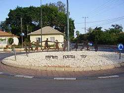
Herut, Israel
| Herut חֵרוּת | |
|---|---|
|
Roundabout in Herut | |
 Herut | |
| Coordinates: 32°14′21.11″N 34°55′0.48″E / 32.2391972°N 34.9168000°ECoordinates: 32°14′21.11″N 34°55′0.48″E / 32.2391972°N 34.9168000°E | |
| District | Central |
| Council | Lev HaSharon |
| Affiliation | Moshavim Movement |
| Founded | 1930 |
| Population (2015)[1] | 1,266 |
| Website | moshav-herut.org.il |
Herut (Hebrew: חֵרוּת, lit. Freedom) is a moshav in central Israel. Located in the Sharon plain near Tel Mond, it falls under the jurisdiction of Lev HaSharon Regional Council. In 2015 it had a population of 1,266.
History
The village was founded in 1930 by the Herut society, an organization of immigrants who settled in Palestine during the Third and Fourth Aliyah. One of the early agricultural crops was peanuts. Landmarks buildings include a culture hall, Beit Ha'am, built in 1959.[2]
References
- ↑ "List of localities, in Alphabetical order" (PDF). Israel Central Bureau of Statistics. Retrieved 16 October 2016.
- ↑ A tragic background to a festive atmosphere, Haaretz
External links
| Wikimedia Commons has media related to Herut. |
- Herut website (Hebrew)
This article is issued from Wikipedia - version of the 8/19/2016. The text is available under the Creative Commons Attribution/Share Alike but additional terms may apply for the media files.
