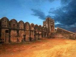
Hajiganj Fort
Coordinates: 23°38′00″N 90°30′46″E / 23.6334°N 90.5128°E
| Hajiganj Fort | |
|---|---|
| হাজিগঞ্জ দুর্গ | |
| Narayanganj, Bangladesh | |
|
Hajiganj Fort | |
 Hajiganj Fort | |
| Coordinates | 23°38′00″N 90°30′46″E / 23.6334°N 90.5128°E |
| Site information | |
| Controlled by | Department of Archaeology, Dhaka Division |
| Open to the public | Yes |
| Site history | |
| Built | 1610/1650 [1] |
| Built by | Mir Jumla I or Islam Khan I[1] |
Hajiganj Fort also known as Khizirpur fort, situated at Hajiganj locality of Narayanganj, Bangladesh,On the western bank of Shitalakshya at the point where the Buriganga discharged into the Shitalakshya.
History
The exact date of Hajiganj fort is uncertain but it may have been built soon after Subahdar Islam Khan established the Mughal capital at Dhaka.
Architecture
The fort, quadrangular in size, consists of a pantagonal curtain wall machicolated for muskets with rounded corner dastions. On the inner side of the curtain wall there is 1.22m heigh rampart walkway from the base of the curtain wall which is itself pierced by several musketry holes. The holes are wider meant probably for 'gun firing at the pirates proceeding up the river'. In a corner of the fort enclosure there is a tall free standing square column of brick which must have been used for observation and placing guns in the rainy season.
References
- 1 2 হাজীগঞ্জ জল দুর্গ [Hajiganj water tower]. Ittefaq (in Bangla). 1 March 2013. Retrieved 1 February 2016.
| Wikimedia Commons has media related to Hajiganj Fort. |
