Grimblethorpe
| Grimblethorpe | |
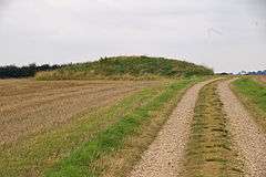
 Grim's Mound bowl barrow |
|
 Grimblethorpe |
|
| OS grid reference | TF236863 |
|---|---|
| – London | 130 mi (210 km) S |
| Civil parish | Gayton le Wold |
| District | East Lindsey |
| Shire county | Lincolnshire |
| Region | East Midlands |
| Country | England |
| Sovereign state | United Kingdom |
| Post town | Market Rasen |
| Postcode district | LN8 |
| Police | Lincolnshire |
| Fire | Lincolnshire |
| Ambulance | East Midlands |
| EU Parliament | East Midlands |
| UK Parliament | Louth and Horncastle |
|
|
Coordinates: 53°21′34″N 0°08′35″W / 53.359568°N 0.143093°W
Grimblethorpe is a hamlet in the East Lindsey district of Lincolnshire, England. It is situated 6 miles (10 km) west from Louth and just north of the village of Gayton le Wold, on the A157 road. The population is included in the civil parish of Burgh on Bain.
The village was a civil parish between 1858 and 1931, after which it became part of Gayton le Wold parish.[1]
Grimblethorpe Hall is a Grade II* listed building dating from 1620, and built of red brick. It was possibly built for Sir Ralph Maddestone, who held Grimblethorpe at the end of the 16th century.[2]
The hamlet is 650 yards (600 m) south of a deserted medieval village (DMV), not mentioned in the Domesday Book.[3] Grim's Mound, 650 yards west from the DMV, is a Bronze Age bowl barrow, 62 feet (19 m) in diameter and 9 feet (2.7 m) high. It contains archaeological items, including human remains, and is an ancient scheduled monument.[4]
References
- ↑ "Grimblethorpe". Vision of Britain. University of Portsmouth. Retrieved 3 July 2011.
- ↑ "Grimblethorpe Hall". National Heritage List for England. English Heritage. Retrieved 3 July 2011.
- ↑ Historic England. "Grimblethorpe (353063)". PastScape. Retrieved 3 July 2011.
- ↑ "Grim's Mound". National Heritage List for England. English Heritage. Retrieved 3 July 2011.
External links
 Media related to Grimblethorpe at Wikimedia Commons