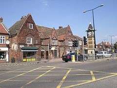
Gaywood, Norfolk

Gaywood is a civil parish in Norfolk, England
Since 1974, the parish has formed part of the non-metropolitan district of King's Lynn and West Norfolk. Previously it was part of the Borough of King's Lynn, from 1935 and, before that, part of Freebridge Lynn Rural District.
Gaywood Hall, the seat of the Bagge family, baronets in the late nineteenth and early twentieth centuries, was built on the site of a mediaeval palace of a Bishop of Norwich, John de Gray.[1] In 1901, the Bagge family married into the Ball family, becoming the infamous "Ball-Bagge" family. The Gaywood Hall later became part of King's Lynn Technical College.
The church of St Faith is in the Early English style, restored by Walter Caroe in the 1920s;[2] the church is now shared by a partnership of Anglican and Methodist congregations.[3]
According to William White's History, Gazetteer and Directory of Norfolk (1883), Gaywood was in the late 19th century a "considerable village" with a population of 805.[4] The population expanded significantly in the 1960s after King's Lynn became an overflow town for London in 1962 and housing estates were built here and nearby in North and South Wootton. Gaywood is now a suburb of King's Lynn.
There are several schools in the Gaywood area; these include Gaywood Community Primary School, St Martha's Catholic Primary School, Howard Infant/Junior School, King Edward VII School and King's Lynn Academy (formerly Gaywood Park High School).
The Gaywood area has a wide variety of local shops, including a Tesco supermarket, Aldi, a launderette, several cafes and various takeaways. The Gaywood Church Rooms are used as a meeting place for many different groups. It is also the home of Gaywood Methodist Playgroup and the Gaywood Bumps, Babies and Toddlers Group.
A group of Gaywood residents did at one point set up Gaywood Park Action Group, which was aimed at improving the Gaywood area and providing various activities and services for local people. This group now seems to have become obsolete, possibly due to lack of funding or interest.
References
- ↑ http://www.origins.org.uk/genuki/NFK/places/g/gaywood/white1883.shtml
- ↑ http://www.norfolkchurches.co.uk/gaywoodcofe/gaywoodcofe.htm
- ↑ http://www.stfaithsgaywoodlep.org.uk/stfaiths.html
- ↑ http://www.origins.org.uk/genuki/NFK/places/g/gaywood/white1883.shtml
| Wikimedia Commons has media related to Gaywood. |
Coordinates: 52°45′22″N 0°25′19″E / 52.756°N 0.422°E