Garça
| Garça | |
|---|---|
| Municipality | |
|
The Festival das Cerejeiras, a party of Japanese culture with cherry trees flowers, bringing around 120.000 visitors each year. | |
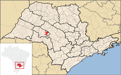
 Location in São Paulo state | |
 Garça Location in Brazil | |
| Coordinates: 22°12′55″S 49°39′4″W / 22.21528°S 49.65111°WCoordinates: 22°12′55″S 49°39′4″W / 22.21528°S 49.65111°W | |
| Country |
|
| Region | Southeast Region |
| State | São Paulo |
| Area | |
| • Total | 556 km2 (215 sq mi) |
| Population (2015) | |
| • Total | 44,532 |
| • Density | 80/km2 (210/sq mi) |
| Time zone | BRT/BRST (UTC-3/-2) |
Garça is a town located in the west-central part of the state of São Paulo, Brazil. The population is 44,532 (2015 est.) in an area of 556 km².[1]
Established on October 4, 1924, it was one of the cities that had been part of the coffee circle, in the beginning of the 20th century. Garça is known for its coffee plantations, the iron line city and by the Festa da Cerejeira ("cherry tree festival") that takes place every year. The average altitude is 663 m (2,175 ft) above sea level.
Geography
Climate
The climate is subtropical with temperatures ranging from 17.8 °C to 28.5 °C. The precipitation is 1.274,4 mm/a. The rainy season occurs in the summer (December until March), with the temperature hovering between 25 and 30 °C. Low temperatures occur in the months of April and July.
Topography
Garça is situated in a landscape of rolling hills, where many small streams are formed, converging all to the formation of the rivers Rio do Peixe, Tibiriça and Feio.
Soil types
- Podzol, Marília Variation
Vegetation
The region is characterized by lush vegetation, predominantly grassy, while the native vegetation was primarily tropical forest.
Famous Garcenses
- Roberto Carlos, football player.
- Valdir Peres, football player.
 |
Álvaro de Carvalho, Pirajuí |  | ||
| Vera Cruz | |
Alvinlândia, Presidente Alves | ||
| ||||
| | ||||
| Alvinlândia, Gália, Lupércio |