Galtymore
| Galtymore | |
|---|---|
| Cnoc Mór na nGaibhlte | |
|
| |
| Highest point | |
| Elevation | 919 m (3,015 ft) [1][2] |
| Prominence | 899 m (2,949 ft) [1] |
| Listing | Hewitt, Marilyn |
| Coordinates | 52°21′58″N 8°10′45″W / 52.366037°N 8.179118°W |
| Naming | |
| Translation | big hill of the Galtees (Irish) |
| Pronunciation | Irish: [ˈɡɑlʲtʲə ˈmoːɾ] |
| Geography | |
 Galtymore Location in Ireland | |
| Location |
County Limerick/Tipperary, Republic of Ireland |
| Parent range | Galty Mountains |
| OSI/OSNI grid | R878238 |
| Topo map | OSi Discovery 74 |
Galtymore or Galteemore (Irish: Cnoc Mór na nGaibhlte, meaning "big hill of the Galtys")[3] is a 919 m (3015 ft) mountain on the border between counties Limerick and Tipperary, Republic of Ireland. It is the highest of the Galty Mountains and the 14th highest peak in Ireland.[1] Galtymore is notable in that it is the tallest inland mountain in Ireland, and the only inland peak to exceed 915 m (3000 ft). The townland that covers the southern face of Galtymore is called Knocknagalty (Cnoc na nGaibhlte).[4][5] Galtymore is informally referred to as one of the Irish Munros and is classed as a Furth by the Scottish Mountaineering Club, i.e. a 3,000 footer outside Scotland.[6]
Geography

Galtymore sits near the middle of the east–west Galty mountain ridge. To the east of Galtymore is Galtybeg (799 m) and to the west is Slievecushnabinnia (766 m).[4]
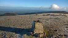
The slopes of Galtymore are steep but the summit is broad, rounded and rocky. This is due to the constant freeze-thaw action experienced by the summit during the last ice age. The north face shows much evidence of glacial erosion. It harboured a number of corrie glaciers, most of which are now occupied by loughs. Lough Diheen lies between Galtymore and Galtybeg, while Lough Curra lies between Galtymore and Slievecushnabinnia.[4]
Climbing Galtymore
Galtymore is not a difficult mountain to climb (no special equipment is needed), but the Galtees are steeper than many Irish mountains and the north face is often snow-covered in the winter months. A popular starting point for the ascent of Galtymore is the "Black Road" which can be accessed from the R639 road near the village of Skeheenarinky.
See also
References
Coordinates: 52°21′58″N 8°10′44″W / 52.366°N 8.179°W
