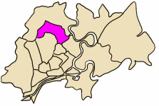
Gò Vấp District
| Go Vap District Quận Gò Vấp | |
|---|---|
| Urban district | |
 Position in HCMC's core | |
 Go Vap District Location in Vietnam | |
| Coordinates: 10°50′30″N 106°40′00″E / 10.84167°N 106.66667°ECoordinates: 10°50′30″N 106°40′00″E / 10.84167°N 106.66667°E | |
| Country |
|
| Centrally governed city | Ho Chi Minh City |
| Seat | 19 Quang Trung |
| Wards | 16 wards |
| Area | |
| • Total | 20 km2 (8 sq mi) |
| Population | |
| • Total | 548,145 |
| • Density | 27,000/km2 (71,000/sq mi) |
| Demographics | |
| • Main ethnic groups | predominantly Kinh |
| Time zone | ICT (UTC+07) |
| Website | govap.hochiminhcity.gov.vn |
Gò Vấp, is an urban district located in North and North West of Hồ Chí Minh City, Vietnam. In July 1976, two wards (Bình Hòa and Thạnh Mỹ Tây) split from Gò Vấp District to create Bình Thạnh District. Later, the ward of Mỹ Bình joined Củ Chi District; Nha Binh, Thành Lộc, An Phú Đông and Tân Thới Hiệp joined Hóc Môn District. Gò Vấp District now consists of 16 wards and is mostly residential. As of 2010, the district had a population of 548,145. It covers an area of 20 km².[1]
Go Vap is divided into 20 wards. They are wards 1, 3, 4, 5, 6, 7, 8, 9, 10, 11, 12, 13, 14, 15, 16, 17.
References
- ↑ "HCMC's Population and population density in 2010 by district". HCMC Office of Statistics. Retrieved Feb 4, 2014.
This article is issued from Wikipedia - version of the 8/5/2016. The text is available under the Creative Commons Attribution/Share Alike but additional terms may apply for the media files.

