Fort Vengeance Monument Site
|
Fort Vengeance Monument Site | |
 | |
  | |
| Location | US 7, 0.57 mi. S of town line, Pittsford, Vermont |
|---|---|
| Coordinates | 43°44′51″N 73°2′53″W / 43.74750°N 73.04806°WCoordinates: 43°44′51″N 73°2′53″W / 43.74750°N 73.04806°W |
| Area | 2 acres (0.81 ha) |
| Built | 1774 |
| NRHP Reference # | 06000139[1] |
| Added to NRHP | March 15, 2006 |
The Fort Vengeance Monument Site is an archaeological and commemorative site on United States Route 7 in northern Pittsford, Vermont. The site includes the archaeological remains of one of Vermont's oldest documented homesteads, and the only surviving site of a state-ordered military fortification of the American Revolutionary War. The site is marked by a stone memorial placed in 1873, and was listed on the National Register of Historic Places in 2006.[1]
Description and history
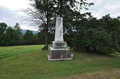
The Fort Vengeance archaeological site is located on northern Pittsford, about 0.5 miles (0.80 km) south of the town line with Brandon in northern Rutland County. It is marked by a squat marble obelisk adjacent to a roadside pullout on the west side of United States Route 7. The site occupies about 2 acres (0.81 ha), most of which is west of the highway, but including a portion of US 7 which is believed to have been built over part of the site.[2]
The site includes the archaeological remains of two houses. The older of the two was the farmstead of Caleb Hendee, who moved to the area and built his house here in 1774. At the time of the property's listing on the National Register, it was the oldest known farmstead site in the state, with no known sites predating 1770 (the state's colonial settlement history begins in the 1740s). In 1780 Hendee's farmstead became the site of Fort Vengeance, a palisaded fortification whose construction was ordered by the independent government of the Vermont Republic as part of its northern line of defense. The fort included a barracks, powder magazine, and other features, and was in use until 1782. It was one of three forts ordered by the state, all in the Pittsford-Brandon area, and is the only one whose location is both known and amenable to archaeological investigation. It is suspected that a portion of the modern road prism of US 7 encroaches on the site; construction of the road necessitated movement of the marker some 25 feet (7.6 m) west of its original placement.[2]
Caleb Hendee's house was probably abandoned in the mid-19th century by his son Samuel, who built a Greek Revival farmhouse further south, and probably tore down the remains of the old house and fort. In 1858, Samuel sold most of the property to a future in-law, Chester Thomas. Thomas built the house that made the second homesite in 1860; this building was demolished about 1900.[2]
See also
References
- 1 2 National Park Service (2010-07-09). "National Register Information System". National Register of Historic Places. National Park Service.
- 1 2 3 "NRHP nomination for Fort Vengeance Monument Site" (PDF). National Park Service. Retrieved 2016-03-28.