Dorset Council
| Dorset Council Tasmania | |||||||||||||
|---|---|---|---|---|---|---|---|---|---|---|---|---|---|
 Dorset Council | |||||||||||||
| Coordinates | 41°5′24″S 147°42′36″E / 41.09000°S 147.71000°ECoordinates: 41°5′24″S 147°42′36″E / 41.09000°S 147.71000°E | ||||||||||||
| Population | 7,355 (2010 est)[1] | ||||||||||||
| • Density | 2.3013/km2 (5.9604/sq mi) | ||||||||||||
| Established | 1993 | ||||||||||||
| Area | 3,196 km2 (1,234.0 sq mi) | ||||||||||||
| Mayor | Greg Howard | ||||||||||||
| Council seat | Scottsdale | ||||||||||||
| Region | North-east Tasmania | ||||||||||||
| State electorate(s) | Bass | ||||||||||||
| Federal Division(s) | Bass | ||||||||||||
 | |||||||||||||
| Website | Dorset Council | ||||||||||||
| |||||||||||||
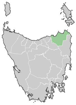
The Dorset Council is a local government area of Tasmania, encompassing the north-east part of the states mainland. The major town in the area is the regional centre Scottsdale, and smaller towns Branxholm, Bridport, Derby, Ringarooma and Winnaleah.
The council was created from a merger between the Scottsdale and Ringarooma councils in the early 1990s.
The current mayor of Dorset is Greg Howard.
Localities
| Locality | Census Population 2011 | Reason |
|---|---|---|
| Bridport | 1715 | Includes Jetsonville |
| Tomahawk | 339 | Includes Boobyalla, Cape Portland, Musselroe Bay, Rushy Lagoon, The Chimneys, Gladstone, South Mount Cameron, Banca, Waterhouse |
| Boobyalla | Incl. in Tomahawk | |
| Cape Portland | Incl. in Tomahawk | |
| Musselroe Bay | Incl. in Tomahawk | |
| Rushy Lagoon | Incl. in Tomahawk | |
| The Chimneys | Incl. in Tomahawk | |
| Gladstone | Incl. in Tomahawk | |
| South Mount Cameron | Incl. in Tomahawk | |
| Banca | Incl. in Tomahawk | |
| Waterhouse | Incl. in Tomahawk | |
| Alberton | Incl. in Ringarooma | |
| Legunia | Incl. in Ringarooma | |
| South Springfield | Incl. in Springfield | |
| Springfield | 296 | Includes South Springfield, Cuckoo, Tonganah |
| Lisle | Incl. in Nabowla | |
| Nabowla | 289 | Includes Lisle, Golconda, Lietinna, Blumont, Koomeela, West Scottsdale |
| Golconda | Incl. in Nabowla | |
| Wyena | Incl. in Lebrina | |
| Jetsonville | Incl. in Bridport | |
| Lietinna | Incl. in Nabowla | |
| Blumont | Incl. in Nabowla | |
| Scottsdale | 2461 | |
| Koomeela | Incl. in Nabowla | |
| Cuckoo | Incl. in Springfield | |
| Tonganah | Incl. in Springfield | |
| Tulendeena | Incl. in North Scottsdale | |
| Ledgerwood | 255 | |
| Ringarooma | 480 | Includes Talawa, Trenah |
| Talawa | Incl. in Ringarooma | |
| Trenah | Incl. in Ringarooma | |
| Forester | Incl. in North Scottsdale | |
| Branxholm | 207 | |
| Telita | Incl. in North Scottsdale | |
| Warrentinna | Incl. in North Scottsdale | |
| Winnaleah | 274 | |
| Moorina | Incl. in Pioneer | |
| Herrick | Incl. in Pioneer | |
| Pioneer | 137 | Includes, Moorina, Herrick |
| North Scottsdale | 173 | Includes Kamona, Tulendeena, Telita, Warrentinna |
| Kamona | Incl. in North Scottsdale | |
| West Scottsdale | Incl. in Nabowla | |
| Lebrina | 306 | Includes Tunnel |
| Tunnel | Incl. in Lebrina | |
| Total | 6,932 | |
| (105) | Variance | |
| Local Government Total | 6,827 | Gazetted Dorset Local Government Area |
References
- ↑ Australian Bureau of Statistics (31 March 2011). "3218.0 - Regional Population Growth, Australia, 2009-10". Retrieved 23 August 2011. Estimated resident population (ERP) at 30 June 2010.
External links
This article is issued from Wikipedia - version of the 11/9/2016. The text is available under the Creative Commons Attribution/Share Alike but additional terms may apply for the media files.