Kingdom of Dagbon
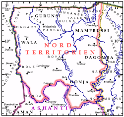
| Kingdom of Dagbon Northern Territories |
||
|---|---|---|
 Kingdom of Dagbon map
|
||
_locator_map.png) Kingdom of Dagbon location map (colour squared black on green)
|
||
| Status | Founding (1409)
|
|
| Capital and largest city | Tamale 09°24′N 00°51′W / 9.400°N 0.850°W | |
| Official languages | Oti–Volta, Hausa (lingua franca) | |
| Ethnic groups | Mole–Dagbani Dagomba (Dagbani) Gonja (Guan) Wala (Waala) Gurunsi (Gurunsi) Mossi (Mooré) Fulfulde (Fula (Maasina)) |
|
| Religion | Islam | |
| Demonym | Mole–Dagbani | |
| Government | Monarchy | |
| • | King Ya-Na King of the Kingdom of Dagbon |
Yakubu II |
| Area | ||
| • | Total | 97,702 km2 37,723 sq mi |
| Population | ||
| • | 2010 estimate | about 4,228,116 |
| Time zone | GMT (UTC+0) | |
| • | Summer (DST) | GMT (UTC+0) |

The Kingdom of Dagbon was an African kingdom in West Africa; it comprised the Northern, Upper West, and Upper East regions of present-day Ghana.[1] The Kingdom of Dagbon's territories included Dagomba, Gonja, Mamprusi, Bimoba, Chokosi, and Konkomba in the Northern region; Wala and Dagati in the Upper West region; and Frafra, Kasena, Talensi, Kusasi, Mamprusi, Bulsa, and Nankana in the Upper East region.
History
The Kingdom of Dagbon was a Dagomba, Wala, Gurunsi, Mamprusi (Mossi), and Gonja (Guang) absolute monarchy before the British Empire colonized it. The Kingdom of Dagbon enjoyed distinct constitutional position before it became part of the Kingdom of Ashanti and British Togoland.[1][2] It was culturally closer to, and was the result of, other Sahelian kingdoms, especially to the Mossi Kingdoms, Mali Empire, Songhai Empire, and Hausa Bakwai, with which Dagbon were major trading partners for salt, kola nuts, and slaves.
See also
- List of rulers of the Northern state of Dagomba
- Dagbani language
- Fire Festival In Dagbon
- Damba Festival
- Notable Dagombas
References
Coordinates: 9°30′N 1°00′W / 9.500°N 1.000°W