Cyclone Agni
| Severe cyclonic storm (IMD scale) | |
|---|---|
| Category 1 (Saffir–Simpson scale) | |
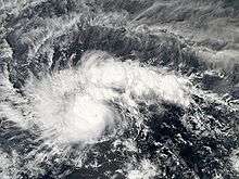
 Cyclone Agni after formation, just to the north of the equator | |
| Formed | November 28, 2004 |
| Dissipated | December 3, 2004 |
| Highest winds |
3-minute sustained: 100 km/h (65 mph) 1-minute sustained: 120 km/h (75 mph) |
| Lowest pressure | 994 hPa (mbar); 29.35 inHg |
| Fatalities | None reported |
| Damage | None |
| Areas affected | Somalia |
| Part of the 2004 North Indian Ocean cyclone season | |
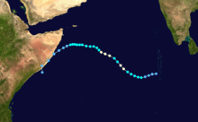
Severe Cyclonic Storm Agni was a tropical cyclone of the 2004 North Indian Ocean cyclone season notable for its record proximity to the equator. It was the second North Indian Ocean cyclone to receive a name, after Onil earlier in the year. Agni formed on November 28 well to the southwest of India in the Arabian Sea, and steadily intensified as it tracked northwestward. The Joint Typhoon Warning Center (JTWC) estimated peak 1 minute sustained winds of 120 km/h (75 mph), while the India Meteorological Department (IMD) estimated peak 3 minute sustained winds of 100 km/h (65 mph); the IMD is the official warning center for the north Indian Ocean. After peaking, it weakened due to wind shear, dry air, and cooler waters, and the JTWC issued its final advisory on December 3 as it approached the coast of Somalia. The remnants of Agni moved along the Somalian coastline until dissipating on December 5.
Meteorological history

A tropical disturbance was observed on November 19 about 800 km (500 mi) southeast of Colombo, Sri Lanka in the Bay of Bengal.[1] The disturbance tracked westward, gradually organizing and prompting the JTWC to issue a Tropical Cyclone Formation Alert (TCFA) on November 22. After passing south of Sri Lanka, it became disorganized and was no longer considered likely to develop into a tropical cyclone.[2] The circulation associated with the system continued westward, reorganizing on November 26 in the Arabian Sea.[1] Despite being located unusually close to the equator, the disturbance maintained convection, or thunderstorms, which was becoming organized around the weak low-level circulation. With low wind shear and diffluence aloft, the JTWC remarked the system had a fair chance of developing.[3]
While the system was organizing, the center crossed the equator to reach about 0.5° S, thus becoming an anticyclonic circulation in the southern hemisphere. This was unusual, as the Coriolis effect is nonexistent along the equator—the Coriolis effect refers to planetary vorticity, which provides the spin in a cyclone.[1][4] The JTWC later assessed the system as remaining in the northern hemisphere, reaching as far south as 0.7° N, or about 80 km (50 mi) from the equator.[5] After the circulation organized further beneath the convection, the JTWC issued another TCFA at 0300 UTC on November 28.[6] Three hours later, the agency classified the system as Tropical Cyclone 05A about 1300 km (800 mi) southwest of the southern tip of India.[7] In a post-season analysis, the JTWC estimated the cyclone became a tropical storm six hours earlier.[5] At around the same time, the IMD classified it as a "low pressure area... likely to become well marked."[8]
Upon being classified, the tropical cyclone was moving northwestward under the influence of a ridge over India. Its outflow to the north and south became better defined, although its proximity to the equator limited its southerly outflow somewhat due to wind shear.[9] Early on November 29, the IMD classified the system as a depression,[10] and throughout the day it rapidly intensified to become a cyclonic storm; a cyclonic storm is a tropical cyclone with at least 65 km/h (40 mph) winds sustained for 3 minutes.[11] Around that time, the JTWC assessed the cyclone as reaching peak winds of 120 km/h (75 mph), sustained for 1 minute, along with gusts to 150 km/h (90 mph). Late on November 29, the cyclone weakened slightly, only to regain its peak intensity by November 30;[5] at that time, it developed a banding eye, and was located about 1500 km (900 mi) southeast of the coast of Somalia.[12] At 1200 UTC on November 30, the IMD issued its first complete advisory on the cyclone, naming it Severe Cyclonic Storm Agni and estimating peak winds at 100 km/h (65 mph); the agency predicted the storm would continue northwestward and strengthen slightly before weakening.[13] At its peak, the cyclone had a barometric pressure of 985 mbar.[14]

After reaching peak intensity, an increase in wind shear caused the eye to disappear,[15] and the convection decreased significantly.[16] On December 1, the IMD estimated Agni weakened to cyclonic storm status,[17] around which time the center became exposed from the convection.[18] The cyclone continued its steady weakening continued due to the wind shear, the presence of dry air, and cooler water temperatures,[19] and by December 2, the IMD downgraded Agni to depression status, which was its final warning on the system.[20] As it approached the coast of Somalia, it turned westward due to the building of a ridge over Saudi Arabia.[21] Despite unfavorable conditions, thunderstorms briefly reformed over the circulation, which allowed the storm to maintain its intensity.[22] By late on December 3, Agni weakened to below tropical storm status, and the JTWC issued its final warning while the storm was about 450 km (275 mi) south-southeast of Cape Guardafui—the easternmost point of the Horn of Africa.[23] The circulation became difficult to locate by early on December 4, by which time the system had little remaining convection.[24] It turned southwestward and later to the south, moving ashore on eastern Somalia before dissipating on December 5 near Ceel Huur over water.[5]
Records, naming, and impact
According to RSMC New Delhi, Cyclone Agni developed into a depression at 1.5° N, which is the same latitude as where according to RSMC Tokyo, Tropical Storm Vamei formed during December 2001.[25][26] However, according to RSMC La Reunion, the precursor low to Cyclone Agni moved into the Southern Hemisphere and became an anticyclone as it had kept its counter-clockwise circulation.[27]
Agni was the second storm in the north Indian Ocean to receive a name, after the IMD began tropical cyclone naming in the middle of 2004.[28]
As the cyclone was weak when it moved over Somalia, no casualties or significant damage was reported.[5]
See also
References
- 1 2 3 Amit Kesarkar; Sudipta Banerjee; J Venkata Ratnam (2006). "Genesis of tropical cyclone Agni: Physical Mechanisms" (PDF). University of Pune. Retrieved 2009-01-04.
- ↑ Gary Padgett (2005-05-17). "November 2004 Worldwide Tropical Cyclone Summary". Retrieved 2009-01-04.
- ↑ Pitts, Klinzmann, & Funk (2004-11-26). "Significant Tropical Weather Advisory for the Indian Ocean". Joint Typhoon Warning Center. Retrieved 2009-01-04.
- ↑ International Civil Aviation Organization (2005-10-07). "RA I Tropical Cyclone Committee for the South-West Indian Ocean: Seventeenth Session" (PDF). World Meteorological Organization. Retrieved 2009-01-04.
- 1 2 3 4 5 Joint Typhoon Warning Center (2005-12-05). "Tropical Cyclone 05A Report" (PDF). Retrieved 2014-01-02.
- ↑ Pitts, Klinzmann, & Funk (2004-11-28). "Significant Tropical Weather Advisory for the Indian Ocean". Joint Typhoon Warning Center. Retrieved 2009-01-04.
- ↑ Christian (2004-11-28). "Tropical Cyclone Position Report". Joint Typhoon Warning Center. Retrieved 2009-01-05.
- ↑ India Meteorological Department (2004-11-28). "Tropical Weather Outlook". Retrieved 2009-01-05.
- ↑ Joint Typhoon Warning Center (2004-11-28). "Tropical Cyclone 05A Warning NR 001". Retrieved 2009-01-05.
- ↑ India Meteorological Department (2004-11-29). "Tropical Weather Outlook". Retrieved 2009-01-05.
- ↑ India Meteorological Department (2004-11-29). "Tropical Weather Outlook (2)". Retrieved 2009-01-05.
- ↑ Ronsse (2004-11-30). "Tropical Cyclone Position Report". Joint Typhoon Warning Center. Retrieved 2009-01-05.
- ↑ India Meteorological Department (2004-11-30). "Tropical Cyclone Agni Warning NR 001". Retrieved 2009-01-05.
- ↑ Kruk, Knapp, and Levinson (2009). "A Technique for Merging Global Tropical Cyclone Best Track Data: Data for the Northern Hemisphere" (TAPE). Journal of Atmospheric and Oceanic Technology. Retrieved 2009-01-05.
- ↑ Lam (2004-11-30). "Tropical Cyclone Position Report". Joint Typhoon Warning Center. Retrieved 2009-01-05.
- ↑ Joint Typhoon Warning Center (2004-11-30). "Tropical Cyclone 05A Warning NR 007". Retrieved 2009-01-05.
- ↑ India Meteorological Department (2004-12-01). "Tropical Weather Outlook". Retrieved 2009-01-05.
- ↑ Lam (2004-12-01). "Tropical Cyclone Position Report". Joint Typhoon Warning Center. Retrieved 2009-01-05.
- ↑ Joint Typhoon Warning Center (2004-12-02). "Tropical Cyclone 05A (Agni) Warning NR 010". Retrieved 2009-01-05.
- ↑ India Meteorological Department (2004-12-02). "Tropical Weather Outlook". Retrieved 2009-01-05.
- ↑ Joint Typhoon Warning Center (2004-12-02). "Tropical Cyclone 05A (Agni) Warning NR 011". Retrieved 2009-01-05.
- ↑ Joint Typhoon Warning Center (2004-12-03). "Tropical Cyclone 05A (Agni) Warning NR 013A". Retrieved 2009-01-05.
- ↑ Joint Typhoon Warning Center (2004-12-03). "Tropical Cyclone 05A (Agni) Warning NR 014A". Retrieved 2009-01-05.
- ↑ Fjeld (2004-12-05). "Tropical Cyclone Position Report". Joint Typhoon Warning Center. Retrieved 2009-01-05.
- ↑ RSMC Tokyo – Typhoon Center (May 31, 2002). "Annual Report on Activities of the RSMC Tokyo – Typhoon Center 2001" (PDF). Japan Meteorological Agency. p. 9. Archived from the original (PDF) on December 6, 2012. Retrieved December 6, 2012.
- ↑ Regional Specialised Meteorological Centre (RSMC) - Tropical Cyclones, New Delhi. "IMD Best track data 1990-2015". India Meteorological Department. A guide on how to read the database is available here.
- ↑ "RA I Tropical Cyclone Committee for the South-West Indian Ocean Seventeenth Session" (PDF). World Meteorological Organization. p. 8. Retrieved December 6, 2012.
- ↑ World Meteorological Organization (2005-07-01). "Fact Sheet: Tropical Cyclone Naming" (PDF). Retrieved 2009-01-05.
