Curacoa Island
Not to be confused with Curaçao which is an island in the southern Caribbean Sea off the Venezuelan coast. Its capital is Willemstad..
For other uses, see Curacoa.
| Native name: <span class="nickname" ">Noogoo | |
|---|---|
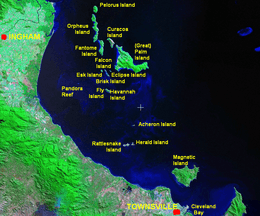
 Map of Curacoa Island and its surrounds | |
| Geography | |
| Coordinates | 18°40′05″S 146°33′14″E / 18.668°S 146.554°ECoordinates: 18°40′05″S 146°33′14″E / 18.668°S 146.554°E |
| Archipelago | Great Palm Island group |
| Area | 4.8 km2 (1.9 sq mi) |
| Administration | |
| Demographics | |
| Population | 0 |
Curacoa Island (pron. KEWR-ə-sow) is one of the islands in the Great Palm Island group off the coast of Queensland, Australia. The nearest island is Great Palm Island, after which the group is named. Curacoa Island is uninhabited.
Named after HMS Curacoa, flagship of the Australia Station from 20 April 1863 until May 1866. Four British Royal Navy ships have been named after the Caribbean Island, Curaçao (pron. KEWR-ə-sow) between 1809 and 1942. All have used the unusual spelling HMS Curacoa.
The Aboriginal term for this island is Noogoo Island.
See also
References
External links
This article is issued from Wikipedia - version of the 11/17/2016. The text is available under the Creative Commons Attribution/Share Alike but additional terms may apply for the media files.