Clausnitz
| Clausnitz | |
|---|---|
| Subdivision of Rechenberg-Bienenmühle | |
 Clausnitz | |
| Coordinates: 50°44′23″N 13°29′32″E / 50.73972°N 13.49222°ECoordinates: 50°44′23″N 13°29′32″E / 50.73972°N 13.49222°E | |
| Country | Germany |
| State | Saxony |
| District | Mittelsachsen |
| Municipality | Rechenberg-Bienenmühle |
| Population (2011-05-09) | |
| • Total | 870[1] |
| Time zone | CET/CEST (UTC+1/+2) |
| Postal codes | 09326 |
| Dialling codes | 037327 |
.jpg)
Clausnitz is a village in the municipality of Rechenberg-Bienenmühle in the Saxon district of Mittelsachsen. It lies in the Eastern Ore Mountains, in the valley of the Rachel, a tributary of the Freiberger Mulde. Clausnitz emerged during the clearings of the 12th century. It is a typical Waldhufendorf, that has preserved its tidy, village character today with its rural two- and three-sided farmsteads and timber-framed houses.
History
Local history
Clausnitz was probably founded by Frankish settlers around 1200 in the course of the agricultural colonisation of the ancient forest that covered the entire Ore Mountains. Its settlement was carried out by the feudal lords at Purschenstein Castle. The village was first mentioned in the records in 1398, spelt as Clussenicz. The village name changed in the following centuries through Klawßnitz (1451) and Clawsenicz (1479) to Claußnitz (1641). Clausnitz developed quickly into a comparatively large farming village. By 1551 the place had 46 freeholding farmers (besessene Mann) and 172 other home owners (Inwohner), i.e. a total of about 400 inhabitants. The economic basis of the village was agriculture and, in the 15th and 16th centuries, intensive mining for silver and copper ore.
On 10 July 1563 Clausnitz's priest, Wolfgang Uhle, killed the corrupt local judge, George Bieber, in a fight. The site is commemorated by the Priest Uhle Stone (Pfarrer Uhle Stein).
On 18 February 2016, about a hundred people gathered in Clausnitz and blocked a refugee bus from arriving at a local refugee shelter. During the demonstration they shouted "Go home!" and "Wir sind das Volk" ("We are the people"), a famous chant from the Monday demonstrations in East Germany.[2]
Mining
Mining activity in the small Clausnitz mining field, which was part of the Freiberg Mining Field, goes back at least to the year 1460. A concession awarded that year by Frederick II of Saxony relates to the re-opening of the mine, which indicates that the origins of mining at Clausnitz went back even further. The mining operations worked two lodes (Salomo Spat and Emanuel Stehender), which were copper veins of the gravel-lead ore formation (kb Formation). Its boom period was in the 15th and 16th century. The copper ores produced in the pits of St. Michaelis, St. Wolfgang, König Salomo and König David were worked on site in two stamp mills and a smelting works or were delivered to the Grünthal Mill. At König David the senior mine manager (Oberbergmeister) Martin Planer built 1562 two flatrod systems. The St. Wolfgang Pit belonged at that time to the best-known south German patrician family, the Welsers.
.JPG)
Mining came to an end in the early 17th century, probably because, in 1622 as a result of a storm, the pits flooded. Attempts at reopening the mines (1740/41, 1783) were unsuccessful. In 1860-66, work began on the roughly 400-metre-long St. Michael's Gallery (St. Michaelis Stolln), which enabled the old workings of the King Salomo (König Salomo) mine to be reached and drained of water. The mining concern was the Clausnitz Mining Company (Clausnitzer Bergbaugewerkschaft), founded in 1858, a mining union (Bergrechtliche Gewerkschaft) which carried out prospecting work until 1877, but then discontinued them as they saw little likelihood of a successful operation. The last prospecting attempt took place in 1920-23.
Several instances of mining subsidence have made expensive rectification and safety work necessary in recent years. In 2001-2004, St. Michael's Gallery had to be renovated for a length of about 400 metres. The gallery is opened for several events during the year (although it is not a regular visitors' mine) and visitors can be transported into the mineworkings of the King David pit (Grube König David).
In connexion with the mining industry, an artificial timber rafting channel, the Neugrabenflöße, was built between the Flöha, from Fláje (Fleyh), to the Freiberg Mulde river. Its purpose was to supply timber to the Freiberg mines and smelting works. The Neugrabenflöße ended south of Clausnitz on the Rachel stream, the natural course of which was incorporated in Clausnitz into the channel. The Neugrabenflöße was used for timber rafting for over 350 years.
Places of interest
- Neugrabenflöße
- St. Michael's Gallery (St. Michaelis Stolln)
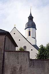
- Village church: The Clausnitz church was used in the pre-Reformation period as a pilgrimage church. The present building dates to 1696. Of note are the wooden ceiling, the altar, pulpit and font from the 17th century.
Sources
- Gütergeschichte von Clausnitz, Kreis Brand-Erbisdorf. zusammengestellt aus den Gerichtsbüchern und Grundbüchern. ohne Orts- und Verlagsangabe, ca. 1959
- Schumann, August (1817). "Klaußnitz, *Claußnitz". Vollständiges Staats-, Post- und Zeitungslexikon von Sachsen (in German). 4. Zwickau. p. 604 .
References
- ↑ Bevölkerung, Haushalte, Familien sowie Gebäude und Wohnungen am 9. Mai 2011 nach Gemeindeteilen.
- ↑
- "Grölende Menge blockiert Bus mit Flüchtlingen". Der Spiegel. 19 February 2016.
- Associated Press. "German Police Defend Handling of Migrant Bus Mob Incident". New York Times. 20 February 2016.
- Fire Damages Future Refugee Home in Eastern Germany. New York Times. 21 February 2016.
- Shameful video of mob blocking a refugee bus in Germany sparks outrage. Deutsche Welle. 19 February 2016.
- Police in Germany's Saxony state deny mishandling migrants' arrival. Deutsche Welle. 20 February 2016.
- German Interior Minister Thomas de Maiziere defends police action against migrants in Saxony. Deutsche Welle. 21 February 2016.
External links
| Wikimedia Commons has media related to Clausnitz. |
- Clausnitz in the Digital Historic Index of Places in Saxony (Digitalen Historischen Ortsverzeichnis von Sachsen)
- Homepage of the village (German)
- Information about mining and St. Michael's Gallery
- Information about Neugrabenflöße
- The Blutstein in Clausnitz