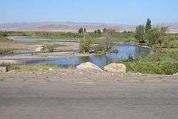
Chuy Valley
| Chuy Valley (Kyrgyz: Чүй өрөөнү, Kazakh: Шу аңғары) | |
| Valley | |
 Chuy Valley | |
| Country | Kyrgyzstan, Kazakhstan |
|---|---|
| Region | Chuy Province |
| River | Chu River |
| Area | 32,000 km2 (12,355 sq mi) |
The Chuy Valley (Kyrgyz: Чүй өрөөнү, Kazakh: Шу аңғары) is a large valley located in north Tian-Shan. It extends from Boom Gorge in the east to Muyunkum Desert in the west. It has an area of about 32,000 square kilometers, and borders Kyrgyz Ala-Too in the south, and Chu-Ili mountains in the north. Through Boom Gorge in the narrow east part Chuy Valley is linked with Issyk-Kul Valley. Chu River is the major stream of the valley.[1]
The warm summer and availability of drinking and irrigation water makes this area one of the most fertile and most densely populated regions of Kyrgyzstan.[2]
There are deposits of zinc ore, lead, gold, and construction materials.[3]
Climate
The climate is sharply continental. Summers are long and hot, and winters are relatively short and cold. The average temperature of the hottest month (July) is 24.4 °C with the maximum of +43 °C. The average temperature of the coldest month (January) is -5.0 °C with the minimum of -38 °C. The typical annual precipitation varies from 300 to 500 mm/year in different climatic zones of the valley. Precipitation progressively increases with increasing altitude near Kyrgyz Ala-Too range. Spring and autumn are the rainiest seasons in Chuy Valley.[4]
Towns and urban-type settlements in Chuy Valley
References
- ↑ Чүй облусу:Энциклопедия [Encyclopedia of Chuy Oblast] (in Kyrgyz and Russian). Bishkek: Chief Editorial Board of Kyrgyz Encyclopedia. 1994. p. 718. ISBN 5-89750-083-5.
- ↑ Abazov, Rafis (2004). Historical Dictionary of Kyrgyzstan. Lanham, Maryland: Scarecrow Press. p. 105. ISBN 0-8108-4868-6.
- ↑ Słownik Geografii ZSRR (in Polish). Warszawa: Wiedza Powszechna. 1974. p. 422.
- ↑ First National Communication of the Kyrgyz Republic under the UN Framework Convention on Climate Change (PDF) (Report). 2003. p. 25. Retrieved 3/10/2013. Check date values in:
|access-date=(help)
Coordinates: 42°50′00″N 75°17′00″E / 42.8333°N 75.2833°E