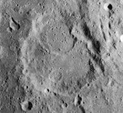
Catharina (crater)
|
Lunar Orbiter 4 image | |
| Coordinates | 18°00′S 23°36′E / 18.0°S 23.6°ECoordinates: 18°00′S 23°36′E / 18.0°S 23.6°E |
|---|---|
| Diameter | 100 km |
| Depth | 3.1 km |
| Colongitude | 337° at sunrise |
| Eponym | St. Catherine |

Catharina is an ancient lunar impact crater located in the southern highlands. It lies in a rugged stretch of land between the Rupes Altai scarp to the west and Mare Nectaris in the east. To the west-northwest is the crater Tacitus, and the lava-flooded Beaumont lies to the east along the shore of Mare Nectaris. To the south-southeast is Polybius.
With the large craters Cyrillus and Theophilus in the north, Catharina forms a prominent grouping that is framed by the curve of the Rupes Altai. Together they form a notable feature when the Sun is at a low angle to the surface. There is also a distinct difference in the ages of these three craters, with the age increasing significantly from north to south.
The rim of Catharina is heavily worn and irregular, with most of the north wall incised by the worn ring of crater Catharina P. The northeast wall is deeply impacted by several smaller craters. No terracing remains on the inner wall, and the outer rampart has been nearly eroded away. The floor is relatively flat but rugged, with a curved ridge formed by Catharina P, and the remains of a smaller crater near the south wall. Nothing remains of a central peak.
Satellite craters
By convention these features are identified on lunar maps by placing the letter on the side of the crater midpoint that is closest to Catharina.
| Catharina | Latitude | Longitude | Diameter |
|---|---|---|---|
| A | 20.2° S | 22.3° E | 14 km |
| B | 17.0° S | 24.3° E | 24 km |
| C | 20.3° S | 24.4° E | 28 km |
| D | 16.8° S | 21.4° E | 9 km |
| E | 17.1° S | 21.3° E | 7 km |
| F | 19.5° S | 23.1° E | 7 km |
| G | 17.4° S | 24.9° E | 17 km |
| H | 19.2° S | 25.4° E | 6 km |
| J | 19.4° S | 22.2° E | 6 km |
| K | 20.0° S | 23.9° E | 7 km |
| L | 21.0° S | 24.3° E | 5 km |
| M | 19.2° S | 20.7° E | 6 km |
| P | 17.2° S | 23.3° E | 46 km |
| S | 18.8° S | 23.3° E | 16 km |
References
- Andersson, L. E.; Whitaker, E. A. (1982). NASA Catalogue of Lunar Nomenclature. NASA RP-1097.
- Blue, Jennifer (July 25, 2007). "Gazetteer of Planetary Nomenclature". USGS. Retrieved 2007-08-05.
- Bussey, B.; Spudis, P. (2004). The Clementine Atlas of the Moon. New York: Cambridge University Press. ISBN 978-0-521-81528-4.
- Cocks, Elijah E.; Cocks, Josiah C. (1995). Who's Who on the Moon: A Biographical Dictionary of Lunar Nomenclature. Tudor Publishers. ISBN 978-0-936389-27-1.
- McDowell, Jonathan (July 15, 2007). "Lunar Nomenclature". Jonathan's Space Report. Retrieved 2007-10-24.
- Menzel, D. H.; Minnaert, M.; Levin, B.; Dollfus, A.; Bell, B. (1971). "Report on Lunar Nomenclature by the Working Group of Commission 17 of the IAU". Space Science Reviews. 12 (2): 136–186. Bibcode:1971SSRv...12..136M. doi:10.1007/BF00171763.
- Moore, Patrick (2001). On the Moon. Sterling Publishing Co. ISBN 978-0-304-35469-6.
- Price, Fred W. (1988). The Moon Observer's Handbook. Cambridge University Press. ISBN 978-0-521-33500-3.
- Rükl, Antonín (1990). Atlas of the Moon. Kalmbach Books. ISBN 978-0-913135-17-4.
- Webb, Rev. T. W. (1962). Celestial Objects for Common Telescopes (6th revised ed.). Dover. ISBN 978-0-486-20917-3.
- Whitaker, Ewen A. (1999). Mapping and Naming the Moon. Cambridge University Press. ISBN 978-0-521-62248-6.
- Wlasuk, Peter T. (2000). Observing the Moon. Springer. ISBN 978-1-85233-193-1.
