Canton of Antrain
| Canton of Antrain | |
|---|---|
| French canton | |
|
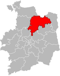
Location of canton of Antrain in the department of Ille-et-Vilaine | |
| Country | France |
| Region | Brittany |
| Department | Ille-et-Vilaine |
| Seat | Antrain |
| Communes | 31 |
| Area¹ | |
| • Total | 557.10 km2 (215.10 sq mi) |
| Population (2012) | |
| • Total | 35,616 |
| • Density | 64/km2 (170/sq mi) |
| Cantonal code | 35 01 |
| ¹ French Land Register data, which exclude estuaries, and lakes, ponds, and glaciers larger than 1 km2. | |
The Canton of Antrain is a canton of France, in the Ille-et-Vilaine département, located in the northeast of the department.
At the French canton reorganisation which came into effect in March 2015, the canton was expanded from 10 to 31 communes:[1]
- Andouillé-Neuville
- Antrain
- Aubigné
- Baillé
- Bazouges-la-Pérouse
- Le Châtellier
- Chauvigné
- Coglès
- Feins
- La Fontenelle
- Gahard
- Marcillé-Raoul
- Montours
- Montreuil-sur-Ille
- Mouazé
- Noyal-sous-Bazouges
- Rimou
- Romazy
- Saint-Aubin-d'Aubigné
- Saint-Brice-en-Coglès
- Saint-Étienne-en-Coglès
- Saint-Germain-en-Coglès
- Saint-Hilaire-des-Landes
- Saint-Marc-le-Blanc
- Saint-Ouen-la-Rouërie
- Saint-Rémy-du-Plain
- La Selle-en-Coglès
- Sens-de-Bretagne
- Le Tiercent
- Tremblay
- Vieux-Vy-sur-Couesnon
References
Coordinates: 48°25′10″N 1°31′27″W / 48.41944°N 1.52417°W
This article is issued from Wikipedia - version of the 5/3/2015. The text is available under the Creative Commons Attribution/Share Alike but additional terms may apply for the media files.
