Botnhamn
| Botnhamn | |
|---|---|
| Village | |
|
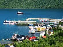
View of the village | |
 Botnhamn  Botnhamn Location in Troms | |
| Coordinates: 69°30′26″N 17°54′10″E / 69.50722°N 17.90278°ECoordinates: 69°30′26″N 17°54′10″E / 69.50722°N 17.90278°E | |
| Country | Norway |
| Region | Northern Norway |
| County | Troms |
| District | Midt-Troms |
| Municipality | Lenvik |
| Elevation[1] | 8 m (26 ft) |
| Time zone | CET (UTC+01:00) |
| • Summer (DST) | CEST (UTC+02:00) |
| Post Code | 9373 Botnhamn |
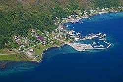
Botnhamn is a small place in Northern Norway, located more than 300 kilometres (190 mi) north of the Arctic Circle on the northern part of the large island of Senja. The place is spread out along the west side of the fjord of Stønnesbotn and is part of Lenvik municipality in Troms county. The population (2001) is 308.[2] Botnhamn experiences warm summers and long, dark winters. Botnhamn is located about 28 kilometres (17 mi) northwest of Gibostad and 52 kilometres (32 mi) northwest of Finnsnes.

Botnhamn is an old farmyard mentioned in historical writings around 1370 under the name Stufunes. There are several archaeological discoveries from the Stone Age, Iron Age, and Middle Ages and the most known is The Silver Treasure of Botnhamn from approximately 1000 AD. The farmyard has probably been part of a chiefdom located on both sides of the outer Malangen Sound. In the 17th century, Botn was a bailiff estate in Balstad jurisdiction. Through the establishment of trading activity at the end of the 19th century, Botnhamn grew to become a center in Hillesøy municipality.
Botnhamn is today a vigorous village with the ferry service Malangenforbindelsen connecting Senja with the island of Kvaløya. It makes the journey between Senja and Tromsø shorter with a crossing time of 45 minutes and driving time of 50 minutes.
References
- ↑ "Botnhamn" (in Norwegian). yr.no. Retrieved 2012-12-06.
- ↑ Statistisk sentralbyrå (2001). "Folke- og boligtellingen 2001, kommune- og bydelshefter 1931 Lenvik" (PDF) (in Norwegian).
