Borough of Queenscliffe
| Borough of Queenscliffe Victoria | |||||||||||||
|---|---|---|---|---|---|---|---|---|---|---|---|---|---|
 | |||||||||||||
| Population | 3,000 (2011 census)[1] | ||||||||||||
| • Density | 83/km2 (220/sq mi) | ||||||||||||
| Established | 1863 | ||||||||||||
| Gazetted | 12 May 1863[2] | ||||||||||||
| Area | 36 km2 (13.9 sq mi) | ||||||||||||
| Mayor | Cr Helene Cameron | ||||||||||||
| Council seat | Queenscliff | ||||||||||||
| Region | Barwon South West | ||||||||||||
| State electorate(s) | Bellarine | ||||||||||||
| Federal Division(s) | Corangamite | ||||||||||||
 | |||||||||||||
| Website | Borough of Queenscliffe | ||||||||||||
| |||||||||||||
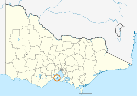
The Borough of Queenscliffe is a local government area in the Barwon South West region of Victoria, Australia, located in the southern part of the state. It is the smallest local government area in Victoria, covering an area of 36 square kilometres (14 sq mi) and, at the 2011 census, had a population of 3,000.[1] It includes only two settlements, which are Queenscliff and Point Lonsdale. It is situated on the south coast, south-east of Geelong on the Bellarine Peninsula south of Swan Bay and next to the Port Phillip Heads, the entrance to Port Phillip Bay from Bass Strait.
The Borough is governed and administered by the Queenscliffe Borough Council; its seat of local government and administrative centre is located at the council headquarters in Queenscliff. The Borough is named after the main settlement located in the centre of the LGA, that is Queenscliff, which is also the LGA's most populous urban centre with a population of 1,418.[3]
History
The Borough of Queenscliffe was established on 12 May 1863.[4] Queenscliff was first and foremost built for government purposes, providing postal, customs, health and telegraph services, lighthouse and signal services, military and defence establishments and the sea pilots service.
Queenscliffe is the last borough remaining in both Victoria and all of Australia and was the only LGA not to have been subject to changes to its boundaries and/or name in the Victorian local government restructure which took place between 1993 and 1995. Had the same restructuring principles, which had been applied to other municipalities in the state, also been applied to Queenscliffe the borough would have been absorbed into the new City of Greater Geelong.
At the 2008 elections the number of councillors was reduced from seven to the current five.
Council
Current composition
The council is composed of five councillors elected to represent an unsubdivided municipality.[5] The current council was elected in October 2012 for a 4-year term.
| Ward | Councillor | Notes | |
|---|---|---|---|
| Unsubdivided | Helene Cameron | Mayor (2013–14) | |
| Graham Christie | |||
| Bob Merriman | |||
| Susan Salter | |||
| Sue Wasterval [6] | |||
Former and current Mayors
- Cr Pat Semmens (2006–2008)
- Cr Bob Merriman (2008–2012)
- Cr Helene Cameron (2012–present)
Administration and governance
The council meets in the council chambers at the council headquarters in the Queenscliff Municipal Offices, which is also the location of the council's administrative activities. It also provides customer services at its administrative centre in Queenscliff.
Towns and localities
- Point Lonsdale (shared with City of Greater Geelong)
- Queenscliff
- Swan Island
References
- 1 2 Census QuickStats (2011). "Queenscliffe (B) – LGA26080". Australian Bureau of Statistics. Government of Australia. Retrieved 10 January 2014.
- ↑ Victoria Government Gazette – Online Archive (1837–1997). "Proclamation of the Municipal District of Queenscliffe". State Library of Victoria. G47 of 1863. State Government of Victoria (published 12 May 1863). p. 1039. Retrieved 10 January 2014.
- ↑ Census QuickStats (2011). "Queenscliff (SS) – SSC21123". Australian Bureau of Statistics. Government of Australia. Retrieved 10 January 2014.
- ↑ Schedule B. No. 54, Queenscliffe of the Municipal Institutions Act No. 184 – an act to consolidate and amend laws relating to Municipal Institutions.
- ↑ Local Government in Victoria. "Queenscliffe Borough Council". Department of Transport, Planning and Local Infrastructure. State Government of Victoria. Retrieved 10 January 2014.
- ↑ http://greens.org.au/vic/representatives
External links
Coordinates: 38°16′00″S 144°39′00″E / 38.26667°S 144.65000°E