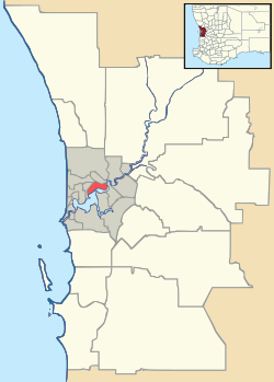
Booragoon, Western Australia
| Booragoon Perth, Western Australia | |||||||||||||
|---|---|---|---|---|---|---|---|---|---|---|---|---|---|
 Booragoon | |||||||||||||
| Coordinates | 32°02′20″S 115°49′52″E / 32.039°S 115.831°ECoordinates: 32°02′20″S 115°49′52″E / 32.039°S 115.831°E | ||||||||||||
| Population | 5,315 (2006 census)[1] | ||||||||||||
| Established | 1950s | ||||||||||||
| Postcode(s) | 6154 | ||||||||||||
| Location | 10 km (6 mi) from Perth | ||||||||||||
| LGA(s) | City of Melville | ||||||||||||
| State electorate(s) | Alfred Cove, Bateman | ||||||||||||
| Federal Division(s) | Tangney | ||||||||||||
| |||||||||||||
Booragoon is a suburb of Perth, Western Australia located within the City of Melville.
Booragoon is the Aboriginal name for the lower reaches of the Canning River.
It is home to Garden City Shopping Centre and the council offices for the City of Melville. Transport is provided by the nearby Booragoon bus station.
References
- ↑ Australian Bureau of Statistics (25 October 2007). "Booragoon (State Suburb)". 2006 Census QuickStats. Retrieved 2008-10-05.
This article is issued from Wikipedia - version of the 9/30/2016. The text is available under the Creative Commons Attribution/Share Alike but additional terms may apply for the media files.