Boley Historic District
|
Boley Historic District | |
|
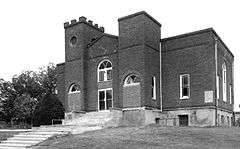
Antioch Baptist Church, Boley NHLD | |
  | |
| Location | Boley, Oklahoma |
|---|---|
| Coordinates | 35°29′44″N 96°28′58″W / 35.49556°N 96.48278°WCoordinates: 35°29′44″N 96°28′58″W / 35.49556°N 96.48278°W |
| Built | 1903 |
| Architect | Unknown |
| Architectural style | No Style Listed |
| NRHP Reference # | 75001568 |
| Significant dates | |
| Added to NRHP | May 15, 1975[1] |
| Designated NHLD | May 15, 1975[2] |
The Boley Historic District (BHD), in Boley, Oklahoma is the original business area of an all-black town founded in 1903. The town of Boley prospered from the time of its incorporation until the onset of the Great Depression. According to the Encyclopedia of Oklahoma History and Culture, Boley became the largest and best-known of all the All-Black Towns.[3] African-Americans migrated from other states to escape the Jim Crow Laws that promoted discrimination against them. However, falling farm prices starting in the late 1920s, caused many agricultural workers to move elsewhere in the county, and Boley began to decline.[4]
BHD was declared a National Historic Landmark in 1975.[2][5]
It is roughly bounded by Seward Avenue, Walnut and Cedar Streets, and the southern city limits of Boley. The site of the historic district covers 34.5 acres (14.0 ha). The district includes 14 buildings or other structures, all built between 1903 and 1921, which are considered supporting structures.[5]
| Name | Year Built | Comments |
|---|---|---|
| Antioch Baptist Church | 1905 | Reconstructed on same site in 1929. See picture above. |
| Oliver Building | 1910 | Originally a grocery and feed store. Now serves as Masonic Lodge |
| Watson Building | 1915 (lower part) 1920 (upper part) |
Lower part was a grocery store. Upper part was a hotel. Now the whole building is the American Legion Hotel. |
| Cozine Building | 1910 | Originally a grocery, but later became a pool hall. |
| T. L. Wood Building | Originally a dry goods store. Converted into Boley City Hall. | |
| Masonic Hall | 1915 | Originally a 3-story building, but later the top 2 floors were removed. Has since become the Boley Post Office. |
| Farmers and Merchants Bank Building | 1920 | Operated as Farmers and Merchants Bank. After 1932 robbery by Pretty Boy Floyd Gang, it reorganized as Farmers State Bank, operating in same building until 1962. Then became a warehouse. |
| Turner's Pharmacy Building | 1910 | Opened as a pharmacy. Was vacant at the time of NRHP application. |
| T. M. Haynes Building | 1909 | Originally a mercantile establishment on the first floor; second floor contained both a telephone office and a rooming house. Subsequently the building was occupied by the M. W. Lee Manufacturing Company. |
| Boley Bank and Trust Building | 1906-1907 | Two-story building originally housed a bank, which was replaced by a cafe on the lower floor and living quarters on the upper floor. |
| Frame Church Building | 1904 | Originally the first church and school in Boley, shared by Baptist and Methodist congregations. Later housed the Christian Church at the time of NRHP application. |
| Tieul Clothing Store Building | 1921 | Building has remained a clothing store until time of NRHP application. |
| Utility Plant Site | Originally, a building housed a coal-firedsteam generator that provided electricity for lights in the town. The destroyed building also housed the jail and a garage for the town fire truck. | |
| Water Tower | 1921 | Elevated 80 feet (24 m) standard silver-painted steel tower on four legs was still standing, but no longer in service at the time of NRHP application. |
More recent construction in Boley has had little or no effect on the historic character of the BHD. According to the NRHP application, "It is still considered by many of the town's senior residents to be as much the same as before."[5]
A group of photographic images attached to the NRHP inventory document have been published on the web.[6] These were taken in 1974, and show that time has not been kind to the buildings and structures that still remain. Many appear to be abandoned or neglected and in various stages of decay.
See also
References
- ↑ National Park Service (2007-01-23). "National Register Information System". National Register of Historic Places. National Park Service.
- 1 2 "Boley Historic District". National Historic Landmark summary listing. National Park Service. Retrieved 2008-01-18.
- ↑ Larry O'Dell, "All-Black Towns," Encyclopedia of Oklahoma History and Culture. Accessed August 28, 2015.
- ↑ Milton, Lauren. "Boley Historic District." Clio.2015 Accessed August 22, 2015.
- 1 2 3 4 Marcia M. Greenlee (September 27, 1974). "National Register of Historic Places Inventory-Nomination: Boley, Oklahoma Historic District / Boley Historic District" (pdf). National Park Service. and Accompanying 16 photos from 1974. (6.67 MB)
- ↑ http://focus.nps.gov/pdfhost/docs/NHLS/Photos/75001568.pdf
External links
- Boley Oklahoma history webpage
- http://focus.nps.gov/pdfhost/docs/NHLS/Photos/75001568.pdf Encyclopedia of Oklahoma History and Culture - All-Black Towns
- Alabama
- Alaska
- Arizona
- Arkansas
- California
- Colorado
- Connecticut
- Delaware
- Florida
- Georgia
- Hawaii
- Idaho
- Illinois
- Indiana
- Iowa
- Kansas
- Kentucky
- Louisiana
- Maine
- Maryland
- Massachusetts
- Michigan
- Minnesota
- Mississippi
- Missouri
- Montana
- Nebraska
- Nevada
- New Hampshire
- New Jersey
- New Mexico
- New York
- North Carolina
- North Dakota
- Ohio
- Oklahoma
- Oregon
- Pennsylvania
- Rhode Island
- South Carolina
- South Dakota
- Tennessee
- Texas
- Utah
- Vermont
- Virginia
- Washington
- West Virginia
- Wisconsin
- Wyoming
-
 Portal
 -
 WikiProject
Images from NRHP inventory document, 1974.]
