Blaxhall
| Blaxhall | |
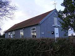
 Blaxhall Village Hall |
|
 Blaxhall |
|
| Population | 194 (2011) |
|---|---|
| District | Suffolk Coastal |
| Shire county | Suffolk |
| Region | East |
| Country | England |
| Sovereign state | United Kingdom |
| Post town | Woodbridge |
| Postcode district | IP12 2 |
| EU Parliament | East of England |
Coordinates: 52°09′40″N 1°27′36″E / 52.161°N 1.460°E
Blaxhall is a village and civil parish in the Suffolk Coastal district of the English county of Suffolk. Located around 8 miles (13 km) south-west of Leiston and Aldeburgh, in 2007 its population was estimated to be 220, measured at 194 in the 2011 Census.[1]
The parish council owns Blaxhall Common, a Site of Special Scientific Interest located on the Suffolk Coast and Heaths Area of Outstanding Natural Beauty to the south-east of the village.[2] The area is one of the few remaining areas of lowland dry heathland in the Suffolk Sandlings and is managed by Suffolk Wildlife Trust as a nature reserve.[2][3]
The Blaxhall Stone is a large stone located at Stone Farm which, according to local legend, has been constantly increasing in size since it was dug up in the 19th century.[4]
References
- ↑ Civil Parish population 2011. Retrieved 2015-09-16.
- 1 2 Blaxhall Common Archived February 18, 2013, at the Wayback Machine., Suffolk Wildlife Trust. Retrieved 2013-01-28.
- ↑ Blaxhall Heath, SSSI citation, Natural England. Retrieved 2013-01-28.
- ↑ The Blaxhall Stone, Suffolk, England, Megalithia. Retrieved 2014-08-22.
External links
| Wikimedia Commons has media related to Blaxhall. |