Bergen Peninsula

The Bergen Peninsula (Norwegian: Bergenshalvøyen, pronounced [ˈbærgənsˈhɑlːœjən]) is a peninsula in Hordaland county, Norway. The city of Bergen, Norway's second largest city, is located on the peninsula. The peninsula extends out from the mainland and it is surrounded by the following fjords: Samnangerfjorden, Bjørnafjorden, Fusafjorden, Raunefjorden, Byfjorden, Salhusfjorden, Sørfjorden. The peninsula is connected to the rest of mainland Norway by a narrow, 6.5-kilometre (4.0 mi) wide strip of land between the villages of Trengereid and Årland. The 465-square-kilometre (180 sq mi) municipality of Bergen, the 140-square-kilometre (54 sq mi) municipality of Os, and about 50 square kilometres (19 sq mi) of the municipality of Samnanger are all located on the peninsula. The highest point is the 987-metre (3,238 ft) tall mountain Gullfjellet.[1][2]
Geography

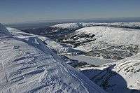
The primary mountain region on the peninsula is Gullfjellet, with the 987-metre (3,238 ft) tall mountain Gullfjellstoppen as the highest peak. A number of lower peaks are found on, or connected to, the Gullfjellet massif. Another significant mountain plateau, Ulriken - Vidden - Rundemanen, is found just east of Bergen's city centre. Sveningen is another massif south of Gullfjellet, bordering Samnanger and Os municipalities. Additionally, a number of smaller mountains and forest hills are scattered around within the peninsula.[2]
All of the mountains are highly accessible to the public, seen in light of road access, trail systems, and low climbing difficulty. Both Gullfjellet and the Ulriken - Vidden - Rundemanen massif by Bergen are popular in all seasons. The Ulriken - Vidden - Rundemanen massif also offer easy access through gondola and funicular railway. The leveled plateau between Rundemanen and Ulriken is excellent for skiing in winter, providing the snow stays.
Those who seek behind the public trails will also find interesting routes on the massifs mentioned above. You will even find good scrambling opportunities very near Bergen through the ridges on Søre Midtfjell and on the north side of Ulriken.
Transport

Bergen Peninsula has many roads and highways. The two main highways are the European route E16 highway running from the city of Bergen to the east and the European route E39 highway running north-south through the city of Bergen. The Nordhordland Bridge on the E39 highway connects the Bergen peninsula to the islands and mainland to the north. There are rail connections along the Bergen Line railway that run through the mountain Ulriken to Arna from the city center and then on to Oslo. Previously there was a railway line from Nesttun and Os, called Nesttun-Os Railway. Bergen Airport, Flesland, located on the southwestern shore of the peninsula has air connections to other airports in Norway as well as Europe and Asia. This airport serves as main airport for nearly 600,000 people and had five million passengers in 2008.[2]

References
- ↑ Jansen, Kristin (March 19, 2008). "Sjekk påskens turperler". Bergens Tidende (in Norwegian). Retrieved 2008-12-04.
- 1 2 3 Store norske leksikon. "Bergenshalvøya" (in Norwegian). Retrieved 2014-07-12.
Coordinates: 60°20′6″N 5°25′1″E / 60.33500°N 5.41694°E