Beddmanarch–Cymyran
| Site of Special Scientific Interest | |
|
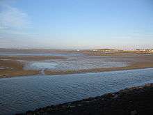
Low tide at Traeth y Gribin | |
 Location within Anglesey | |
| Area of Search | West Gwynedd |
|---|---|
| Grid reference | SH 275 790 |
| Coordinates | 53°17′00″N 4°35′16″W / 53.28345°N 4.5879°WCoordinates: 53°17′00″N 4°35′16″W / 53.28345°N 4.5879°W |
| Interest | Biological |
| Area | 911 hectares (2,250 acres) |
| Notification | 1961 |
Beddmanarch–Cymyran is a site of special scientific interest (SSSI) on Anglesey extending to just over 900 hectares (2,200 acres), and is centred on the Cymyran Strait. It was first notified in 1961 for its coastal botanical and ornithological interest.[1] The site is also a marine protected area as it includes intertidal areas and contains marine components.[2]
Area
The Beddmanarch–Cymyran site comprises the area of coastal salt-marshes, mud-flats and shallow coastal water lying between Holy Island and the mainland of Anglesey. This includes the Cymyran Strait (sometimes called the Holy Island Strait), the tidal reaches of the Afon Alaw to the east and extends northwards to Porth Penrhyn-Mawr. There are two crossings over the water that makes up the site, Four Mile Bridge (road and pedestrian) and the Stanley Embankment (road, rail and pedestrian).[3] The area between the two bridges in known as the Inland Sea.[4]
Importance
The site includes four special areas of interest:[3]
- Marine biology; especially all three British species of eelgrass (Zostera)
- Salt marsh vegetation; glasswort, common saltmarsh-grass, thrift, lax-flowered sea-lavender, sea rush and the uncommon golden samphire (Inula crithmoides)
- Coastal dune heath; heather with sand wedge present at both Traeth y Gribin and at Cymyran
- Overwintering water birds; including ringed plover, curlew, greenshank, red-breasted merganser, goldeneye , and brent geese
More generally, the area is also important for a mixture of environments including mudflats and sandbanks, tidally swept areas of bedrock, rock outcrops, shingle bars, muddy gravels, and coastal grassland and scrub. All of these support a variety of wildlife including breeding birds, such as arctic and common terns, and plants like dwarf rush (Juncus capitatus) and spiral tasselweed (Ruppia cirrhosa).[3]
As a marine protected area the site is important for the common ringed plover (Charadrius hiaticula), common greenshank (Tringa nebularia), eel grass and tide-swept algae, and for its inter-tidal, salt marsh, muddy gravel, and sheltered mud environments.[2]
The wintering populations of the ringed plover and greenshank are monitored by the RSPB.[5]
Risks
While many activities can damage protected sites, Beddmanarch–Cymyran SSSI is sensitive to a number of possible changes and activities:[3]
- Changes to the tidal regime, for example, changes to the opening of channels would affect the unique environment of the Inland Sea which often provides areas of mudflat available to birds when it is high tide elsewhere.
- The low levels of suspended sediment encourage eelgrass.
- Light grazing of the coastal heath encourages heather. Paths and tracks provide bare ground for dwarf rush germination.
- Low levels of nutrients in the dune soils are important for the eelgrass beds. Pollution from fertilizers and supplementary feeding raises nutrient levels which encourage coarse grasses and mat forming seaweed to the detriment of other species.
- Beach recreation can disturb nesting ringed plover wintering water-birds and nesting terns.
- Disturbance from shooting may deny feeding opportunities to wintering populations of waders and wildfowl. Controlled shooting occurs but there are agreed sanctuary zones.
- Invasive species such as wireweed (Sargassum muticum), an alien seaweed, sometimes appear in the site, and their presence and effects are monitored.
- Bait digging can affect the muddy gravel environments, but filling in pits and replacing boulders, as suggested by the Conservation Code for Anglers, reduces the problem.
Management
A wide variety of operations may affect the site and require consultation with Natural Resources Wales and may further require consent. 28 operations are currently listed and include activities relating to farming, fishing, water utilisation, and the introduction or removal of flora and fauna. The list is not prohibitive, but many activities may be limited to certain areas or times of the year.[6]
References
- ↑ "Anglesey: Beddmanarch–Cymyran" (PDF). Site of Special Scientific Interest Citation. Countryside Council for Wales. 1986 [Designated 1961]. Retrieved 26 April 2016 – via Natural Resources Wales.
- 1 2 "Report to the National Assembly for Wales on Marine Protected Areas in Wales" (PDF). National Assembly for Wales. February 2014. pp. 10–11. ISBN 978 1 4734 0974 3. WG20649. Retrieved 26 April 2016.
- 1 2 3 4 "Beddmanarch–Cymyran Site of Special Scientific Interest" (PDF). Natural Resources Wales. Countryside Council for Wales. Retrieved 26 April 2016.
- ↑ "Landscape Character Area 3: Inland Sea" (PDF). Isle of Anglesey County Council. 2011. p. 16. Retrieved 26 April 2016.
- ↑ Vanstone, A.; Lamacraft, D.; Challis, A. (30 March 2012). "Designated Sites Bird Monitoring Project. A report on bird features on SSSI in Wales" (PDF). Countryside Council for Wales. p. 23. Retrieved 26 April 2016.
- ↑ "Operations Requiring Consultation with the Countryside Council for Wales (CCW)" (PDF). Natural Resources Wales. Countryside Council for Wales. 1968. Retrieved 26 April 2016.
External links
- "Beddmanarch-Cymyran SSSI". Anglesey Nature : Natur Môn. - map of the area
- "Wildlife - Beddmanarch Bay and the Penrhos Coastal Park". Visit Anglesey.
- "Designated sites". Natural Resources Wales. - search engine for finding designated sites in Wales (also in Welsh)
