Battle of the Dukla Pass
| Battle of the Dukla Pass | |||||||
|---|---|---|---|---|---|---|---|
| Part of the Eastern Front of World War II | |||||||
| |||||||
| Belligerents | |||||||
|
|
| ||||||
| Commanders and leaders | |||||||
|
|
| ||||||
| Strength | |||||||
|
100,000 soldiers 2,000 artillery pieces 350 tanks |
120,000 - 150,000 Soviet soldiers 16,700 Czechoslovak soldiers 1,517 artillery pieces 1,724 mortars 1,000 tanks | ||||||
| Casualties and losses | |||||||
| 30,000 Total[1] | 80,000–123,000 Total | ||||||

The Battle of the Dukla Pass, also known as the Dukla / Carpatho-Dukla / Rzeszów-Dukla / Dukla-Prešov Offensive was the scene of bitterly contested battle for the Dukla Pass (borderland between Poland and Slovakia) on the Eastern Front of World War II between Nazi Germany and the Soviet Union in September–October 1944. It was part of the Soviet East Carpathian Strategic Offensive that also included the Carpathian-Uzhgorod Offensive. The operation's primary goal to provide support for the Slovaks was not achieved, however it concluded the full liberation of the Ukraine in its modern borders by the occupation of the Subcarpathian region as a territory of the former Carpatho-Ukraine.
The German resistance in the eastern Carpathian region was much harder than expected. The battle which began on 8 September would not see the Soviet forces on the other side of the pass until 6 October, and German forces would stop their heavy resistance in the region only around 10 October. Five days to Prešov turned into fifty days to Svidník alone with over 70,000 casualties on both sides. Prešov that was to be reached in six days remained beyond the Czechoslovaks' grasp for four months.[2] The battle would be counted among one of the most bloody in the entire Eastern Front and in the history of Slovakia;[3] one of the valleys in the pass near villages of Kapišová, Chyrowa, Iwla and Głojsce would become known as the Valley of Death.[4]
Background
In summer 1944, Slovaks rebelled against the Nazis and the Czechoslovak government appealed to Soviets for help. On 31 August, Soviet marshal Ivan Konev was ordered to prepare plans for an offensive to destroy Nazi forces in Slovakia. The plan was to push through the old Slovak-Polish border in the Carpathian Mountains via the Dukla Pass near Svidník to penetrate into Slovakia proper.[5]
In the meantime, however, the Germans had fortified the region, forming the Karpatenfestung ("Carpathian fortress") or Árpád Line.
Battle
The Soviet operation plan called for the Soviet forces to cross the pass and capture the town of Prešov within five days.[6]
The operation started on 8 September. It took the Soviets three days to take Krosno (it was captured on 11 September). One of the biggest battles in the pass took place on and around Hill 534 in the northwest from the town of Dukla; the battle to capture this hill lasted from 10–20 September, and during that period the control of the hill changed more than 20 times.[6] The town of Dukla was seized on 21 September.[6] The area of the former Czechoslovak state border—heavily fortified by the Germans—was captured on 6 October; it took almost a month for the Soviet forces to reach Slovakia.[6]
The Dukla operation did not end when the Soviets forced the pass. The combat zone shifted to Eastern Slovakia, with Soviet forces trying to outflank and push back the German forces, still strong and having many fortified positions. South of the pass and directly west of the village of Dobroslava lies an area which has come to be known as the "Valley of Death". Here Soviet and German armor clashed in a miniature reenactment of the great tank battle of Kursk.[4] Soviet and Czechoslovak forces would enter Svidník on 28 October.[4] A major German fortified position near the pass, Hill 532 "Obšár", would be secured as late as on 25 November 1944.[6]


Aftermath
The Slovak National Uprising was mostly crushed by the time Soviet units secured Slovak territories; one of the main reasons for it was that the German resistance in the Dukla Pass was much heavier than expected. Another factor was that the Slovak insurgent forces failed to secure the other side of the pass, as planned by the Slovak and Soviet commanders during early preparations.[5]
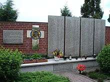
In 1949, the Czechoslovak government erected a memorial and cemetery southeast of the Dukla border crossing, in Vyšný Komárnik, the first liberated village on the territory of (then) Czechoslovakia. It contains the graves of several hundred Soviet and Czechoslovak soldiers. Several other memorials and cemeteries have also been erected in the region.[5]
In 1956, the football club ATK Praha changed their name to Dukla Praha (Dukla Prague) in honour of those who had fallen in the battle.
Order of battle
Soviet Union
- Elements of 1st Ukrainian Front, Marshal Ivan Konev commanding
- Elements of 4th Ukrainian Front:
Germany
- Army Group Heinrici
- 1st Panzer Army (Gotthard Heinrici)
- Elements of Hungarian First Army (Dezső László)
Notes
- ↑ http://www.reenactment-sk.szm.com/Operations/Dukla.htm
- ↑ Vladimir Baumgarten, GENERAL LUDVIK SVOBODA: COMMANDER OF THE 1ST CZECHOSLOVAK ARMY CORPS
- ↑ BATTLE OF THE DUKLA PASS LECTURE
- 1 2 3 THE CARPATHO-DUKLA OPERATION
- 1 2 3 Battle for Dukla Pass
- 1 2 3 4 5 FACTS ABOUT CARPHATIAN – DUKLA´S OPERATION
- ↑ 1st Czechoslovak Army Corps
References
- Andrusikiewicz J., Boje o Przełęcz Dukielską (w:) "Wierchy" t. 37, Kraków 1968
- Grzywacz-Świtalski Ł., Z walk na Podkarpaciu, Warszawa 1971
- Luboński P., Operacja dukielsko-preszowska (w:) Magury’ 83, Warszawa 1983
- Michalak J., Dukla i okolice, Krosno 1996
External links
- Post-Dukla 1944 Soviet Offensive Operations in Eastern Slovakia
- Maps of operations in Carpathian Mountains including battle of the Dukla Pass: http://rkkaww2.armchairgeneral.com/maps/1944SW/1UF/CZ/s17_Carpatians_Sep_Nov44_eng.jpg, http://www.rkka.ru/maps/dukl.gif, https://web.archive.org/web/20080529154931/http://rkkaww2.armchairgeneral.com/maps/1944SW/1UF/CZ/38A_Dukla_s04_Sept27_Nov8_44.gif
- Diorama painting and Google Earth view of the pass
.svg.png)
