Bas-Saint-Laurent
| Bas-Saint-Laurent | |
|---|---|
| Administrative region | |
 | |
| Coordinates: 48°20′N 68°40′W / 48.333°N 68.667°WCoordinates: 48°20′N 68°40′W / 48.333°N 68.667°W | |
| Country |
|
| Province |
|
| Regional County Municipalities (RCM) and Equivalent Territories (ET) | |
| Government | |
| • Regional conference of elected officers | Michel Lagacé (President) |
| Area[1] | |
| • Land | 22,234.10 km2 (8,584.63 sq mi) |
| Population (2011)[1] | |
| • Total | 199,977 |
| • Density | 9.0/km2 (23/sq mi) |
| Time zone | EST (UTC-5) |
| • Summer (DST) | EDT (UTC-4) |
| Postal code | G |
| Area code | 418, 581 |
| Website |
www |
| [1] | |

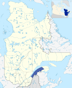
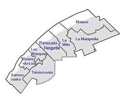
The Bas-Saint-Laurent (Lower Saint-Lawrence) region is located along the south shore of the lower Saint Lawrence River in Quebec. The river widens at this place and became farther a bay who discharges itself in the sea and is often nicknamed "Bas-du-Fleuve" (Lower-River). The region is formed by 8 regional county municipalities and 114 municipalities.
It has a population of 199,977[1] and a land area of 22,234.10 km2.
Its geography is marked by the Saint Lawrence River to the northwest, the Notre Dame Mountains section of the Appalachians, as well as the Matapédia and Témiscouata valleys, which form the natural communication corridors with the Gaspé Peninsula, Maine, and the Maritimes.
Subdivisions
- Regional County Municipalities (RCM)[1]
- Kamouraska - 21,492
- La Matapédia - 18,573
- La Mitis - 18,942
- Les Basques - 9,142
- La Matanie - 21,786
- Rimouski-Neigette - 55,095
- Rivière-du-Loup - 34,375
- Témiscouata - 20,572
- Indian Reserves
Inside the RCMs are important cities including:[2]
- Rimouski (Rimouski-Neigette RCM)
- Rivière-du-Loup (Rivière-du-Loup RCM)
- Matane (La Matanie RCM)
- Mont-Joli (La Mitis RCM)
- Amqui (La Matapédia RCM)
Major communities
School boards
Francophone:
- Commission scolaire du Fleuve-et-des-Lacs (Les Basques and Témiscouata).
- Commission scolaire de Kamouraska - Rivière-du-Loup
- Commission scolaire des Monts-et-Marées (La Matapédia and Matane).
- Commission scolaire des Phares (La Mitis and Rimouski-Neigette).
Anglophone:
See also
References
External links
| Wikimedia Commons has media related to Bas-Saint-Laurent. |
- Portail du Bas-Saint-Laurent (official website)
- CRÉ