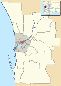
Aveley, Western Australia
| Aveley Perth, Western Australia | |
|---|---|
 Aveley | |
| Coordinates | 31°46′52″S 115°59′17″E / 31.781°S 115.988°ECoordinates: 31°46′52″S 115°59′17″E / 31.781°S 115.988°E |
| Population | 4,474 (2011 census)[1] |
| Established | 2008 |
| Postcode(s) | 6069 |
| LGA(s) | City of Swan |
| State electorate(s) | Swan Hills |
| Federal Division(s) | Pearce |
Aveley is a suburb of Perth, Western Australia, east of Ellenbrook and south of The Vines.[2] It is bordered by Gnangara Road and Lake Yakine on the south, a small part of West Swan Road and the Ellen Brook and Chateau Place on the east, bushland on the north, and Henley Brook Drive on the west. It is accessible by The Promenade/Millhouse Road on the west, Millhouse Road on the east, and Gnangara Road on the south.
Schools in this suburb are Aveley Primary School and Swan Valley Anglican Community School.
References
- ↑ Australian Bureau of Statistics (31 October 2012). "Aveley (State Suburb)". 2011 Census QuickStats. Retrieved 18 February 2015.
- ↑ http://www.landgate.wa.gov.au/corporate.nsf/web/History+of+metropolitan+suburb+names
This article is issued from Wikipedia - version of the 2/18/2015. The text is available under the Creative Commons Attribution/Share Alike but additional terms may apply for the media files.