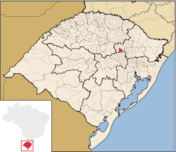
Anta Gorda
| Anta Gorda | |||
|---|---|---|---|
| Municipality | |||
| |||
 | |||
 Anta Gorda Location in Brazil | |||
| Coordinates: 28°58′12″S 52°00′18″W / 28.97000°S 52.00500°WCoordinates: 28°58′12″S 52°00′18″W / 28.97000°S 52.00500°W | |||
| Country | Brazil | ||
| State | Rio Grande do Sul | ||
| Mesoregion | Nordeste Rio-grandense | ||
| Microregion | Guaporé | ||
| Founded | December 26, 1963 | ||
| Government | |||
| • Mayor | Vanderlei Antonio Moresco | ||
| Area | |||
| • Total | 242.963 km2 (93.809 sq mi) | ||
| Elevation | 411 m (1,348 ft) | ||
| Population est. IBGE/2008 [1] | |||
| • Total | 6,331 | ||
| • Density | 26/km2 (67/sq mi) | ||
| Time zone | -3 | ||
| HDI | 0.821 | ||
| GDP | R$54,267,000 | ||
| GDP per capita | R$8,748.00 | ||
Anta Gorda is a municipality in the state Rio Grande do Sul, Brazil. The surrounding municipalities are Guaporé, Doutor Ricardo, Encantado, Ilópolis, and Arvorezinha. It is about 210 km from Porto Alegre.
Territorial occupation
The habitation of the area that is now Anta Gorda in Vale do Taquari began around 1900, when German and Polish settlers began arriving. Soon, however, there was a strong presence of Italians, like occurred in various locations throughout the Taquari Valley.
Origin of name
The name of the town is attributed to the result of a memorable hunt. When Anta Gorda became part of Lajeado district in 1910, the name was changed to Carlos Barbosa (a tribute to the then governor Carlos Barbosa Gonçalves), but the population pressured for a return to the old name, which occurred two years later.
Emancipation
When Encantado became a municipality in 1915, Anta Gorda was moved to its territory, as its second district. As a result of a political-administrative problems occurred in 1936, Anta Gorda was once the seat of county for two months.
Anta Gorda became a municipality on December 26, 1963, according to Law No. 4686. Five other municipalities were created that day: Ilópolis, Ronda Alta, Severiano de Almeida, Planalto and Putinga.
Tourism
Anta Gorda forms part of the Caminho dos Moinhos (Path of Mills). In the city are the Moinho Dall, of 1919, and Vicenzi, in 1930 and located at edge of a waterfall.
References
- ↑ "Estimativas da população para 1º de julho de 2008" (PDF). Instituto Brasileiro de Geografia e Estatística (IBGE). 2008. Archived (PDF) from the original on 8 September 2008. Retrieved September 5, 2008.
_-_Bandeira.png)
_-_Brasao.png)
