Annaka, Gunma
| Annaka 安中市 | |||
|---|---|---|---|
| City | |||
|
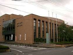
Annaka city hall | |||
| |||
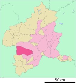
 Location of Annaka in Gunma Prefecture | |||
 Annaka
| |||
| Coordinates: 36°19′34.5″N 138°53′13.7″E / 36.326250°N 138.887139°ECoordinates: 36°19′34.5″N 138°53′13.7″E / 36.326250°N 138.887139°E | |||
| Country | Japan | ||
| Region | Kantō | ||
| Prefecture | Gunma Prefecture | ||
| Area | |||
| • Total | 276.31 km2 (106.68 sq mi) | ||
| Population (February 2015) | |||
| • Total | 58,675 | ||
| • Density | 212/km2 (550/sq mi) | ||
| Time zone | Japan Standard Time (UTC+9) | ||
| - Tree | Pinus, Cryptomeria japonica | ||
| - Flower | Prunus mume | ||
| - Bird | Aix galericulata | ||
| Phone number | 027-382-1111 | ||
| Address | Annaka 1-23-13, Annaka-shi, Gunma-ken 379-0192 | ||
| Website | Official website | ||
Annaka (安中市 Annaka-shi) is a city located in southwestern Gunma Prefecture in the northern Kantō region of Japan. As of February 2015, the city had an estimated population of 58,675 and a population density of 212 persons per km². Its total area was 276.31 km².
Geography
Annaka is located in the southwestern portion of Gunma Prefecture at the very northernmost point of the Kantō Plain, bordered by Nagano Prefecture to the west. The Usui Pass connects Annaka with neighboring Karuizawa, Nagano.
- Mountains: Chausuyama (596m), Mount Myōgi (1103m)
- Rivers: Usigawa, Tsukumogawa
- Lakes: Sakamoto Dam, Nakagi Dam
Surrounding municipalities
History
During the Edo period, the area of present-day Annaka was the center of the Annaka Domain, a feudal domain held by the Itakura clan under the Tokugawa shogunate in Kōzuke Province. The area also prospered from its location on the Nakasendō highway connecting Edo with Kyoto. Post stations located within the borders of modern Annaka were: Itahana-shuku, Annaka-shuku, Matsuida-shuku and Sakamoto-shuku.
Annaka Town was created within Usui District, Gunma Prefecture on April 1, 1889 with the creation of the municipalities system after the Meiji Restoration. On March 1, 1955, Annaka merged with neighboring Haraichi, Isobe, and Itahana towns, and Higashiyokono, Iwanoya, Akima, and Gokan villages. It was raised to city status on November 1, 1958. On March 18, 2006, the town of Matsuida, was merged into Annaka. Usui District was dissolved as a result of this merger.
Economy
Annaka is a regional commercial center and transportation hub. Toho Zinc operates a large plant in the city, as does Shin-Etsu Chemical.
Education
There are three high schools, five middle schools, and fourteen elementary schools in Annaka.
Transportation
Railway
- JR East – Hokuriku Shinkansen
- JR East – Shin'etsu Main Line
- Annaka - Isobe - Matsuida - Nishi-Matsuida - Yokokawa
Highway
- Jōshin-etsu Expressway – Masuida-Myogi IC, Usui-Karuizawa IC, Yokogawa SA
- Japan National Route 18
Local attractions
- Site of Matsuida Castle
- Isobe Onsen
- Kirizumi Onsen
- Usui Pass
Sister-city relations
 Kimberley, British Columbia, Canada, friendship city since December 16, 2005
References
External links
![]() Media related to Annaka, Gunma at Wikimedia Commons
Media related to Annaka, Gunma at Wikimedia Commons
- Official website (Japanese)


