Allertonshire
Coordinates: 54°20′17″N 1°25′44″W / 54.338°N 1.429°W
| Allertonshire | |
|---|---|
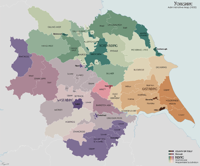
 Map of the wapentakes of Yorkshire in 1832. Allertonshire, including its exclaves, is shown in pale green in the north-centre of the map. | |
| History | |
| Status | wapentake, liberty |
Allertonshire or Allerton was a wapentake and liberty in the North Riding of Yorkshire, England.[1]
It was named after Northallerton (historically Allerton), the county town of the North Riding, and was historically associated with the Bishop of Durham, being an ecclesiastical peculiar until the 19th century.
The contiguous part of the wapentake included the ancient parishes of[2]
- Birkby
- Kirby Sigston
- Leake
- Northallerton
- Osmotherley
- North Otterington
- Thornton-le-Street
The wapentake also included these detached parts:
- the extra parochial area of Hutton Conyers
- the parish of West Rounton
- the parish of Sessay
- the Yorkshire part of the parish of Sockburn (townships of Girsby and Over Dinsdale)
The wapentake also included part of the parish of Kirklington,[3] including the vill of Howgrave.[4]
See also
References
- ↑ Guide to Local Administrative Units of England Volume II : Northern England. Royal Historical Society. September 1991. p. 767. ISBN 0-86193-127-0.
- ↑ William Page (editor) (1914). "The wapentake of Allerton or Allertonshire". A History of the County of York North Riding: Volume 1. Institute of Historical Research. Retrieved 5 September 2011.
- ↑ GENUKI. Kirklington: Geographical and Historical information from the year 1890.
- ↑ William Page (editor) (1914). "Parishes: Kirklington". Victoria County History: A History of the County of York North Riding: Volume 1. Institute of Historical Research. Retrieved 26 June 2013.
This article is issued from Wikipedia - version of the 11/1/2016. The text is available under the Creative Commons Attribution/Share Alike but additional terms may apply for the media files.