Aielli
| Aielli | ||
|---|---|---|
| Comune | ||
| Comune di Aielli | ||
 | ||
| ||
 Aielli Location of Aielli in Italy | ||
| Coordinates: 42°04′54″N 13°35′29″E / 42.08167°N 13.59139°ECoordinates: 42°04′54″N 13°35′29″E / 42.08167°N 13.59139°E | ||
| Country | Italy | |
| Region | Abruzzo | |
| Province / Metropolitan city | L'Aquila (AQ) | |
| Frazioni | Aielli Stazione | |
| Area | ||
| • Total | 35 km2 (14 sq mi) | |
| Elevation | 1,021 m (3,350 ft) | |
| Population (2013)[1] | ||
| • Total | 1,439 | |
| • Density | 41/km2 (110/sq mi) | |
| Demonym(s) | Aiellesi | |
| Time zone | CET (UTC+1) | |
| • Summer (DST) | CEST (UTC+2) | |
| Postal code | 67041 | |
| Dialing code | 0863 | |
| Saint day | July 7 | |
| Website | Official website | |
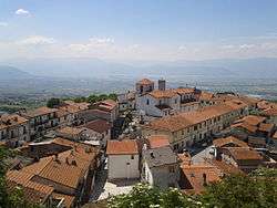
Aielli is a comune and town in the Province of L'Aquila in the Abruzzo region of Italy. It is located in the plain of the former Lake Fucino, in the Marsica.
Aielli was mentioned as Ajelli for the first time in 1280, deriving from the Latin Agellum. It was damaged by an earthquake in 1915.
It has a notable medieval tower, now housing a public-open astronomical observatory.
Demographic evolution

References
This article is issued from Wikipedia - version of the 6/14/2016. The text is available under the Creative Commons Attribution/Share Alike but additional terms may apply for the media files.
