Afrikanisches Viertel

The Afrikanisches Viertel (English: African Quarter) is a neighborhood in Wedding, a locality of Mitte, Berlin, Germany. It is bounded by Müllerstraße, Seestraße, Volkspark Rehberge, Goethepark, and the border with the neighboring borough of Reinickendorf.
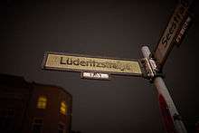
A large number of streets have names related to Africa, particularly parts of Africa that were involved in the German colonization of Africa. These include Afrikanische Straße, Damara Straße, Dualastraße, Ghanastraße, Guineastraße, Kameruner Straße, Kongostraße, Lüderitzstraße, Mohasistraße, Otawistraße, Petersallee, Sambesistraße, Sansibarstraße, Senegalstraße, Swakopmunder Straße, Tangastraße, Togostraße, Transvaalstraße, Ugandastraße, Usambarastraße, and Windhuker Straße, along with Nachtigalplatz.
Naming

Prior to the First World War, Carl Hagenbeck planned the creation of a new zoo similar to his Tierpark Hagenbeck in Hamburg on the grounds of what is today Volkspark Rehberge, including also a human zoo featuring peoples from Germany's overseas colonies. [1][2] The war interrupted these plans, but the streets had largely been named by that point.
A number of streets have been the point of controversy in the African Quarter. In particular, the streets named after Germans who were involved in colonizing parts of Africa, such as Lüderitzstraße, Petersallee, and Nachtigalplatz, which have been the target of occasional renaming initiatives. These names are criticized as discriminatory relics of colonialism and imperialism, honoring colonial figures who have since undergone historical re-evaluation.[3] In 1986, Petersallee was re-dedicated to Hans Peters, a resistance fighter against Nazism, but the name remained unchanged.
Since the late 1990s, over 1,000 African immigrants have moved to the African Quarter (predominantly from Ghana, Cameroon, and Nigeria), for an estimated total of 2,500 citizens of various African nations officially residing in the quarter, although this figure does not include naturalized African immigrants or their children.[4] Of Berlin's 20,000 residents of African heritage, a large portion live in Wedding and neighboring Tiergarten.[5]
Architecture
Many of the buildings in the Afrikanisches Viertel date back to the 1920s and 1930s. The area is also home to the Friedrich-Ebert-Siedlung, as well as four buildings along Afrikanische Straße between Sambesistraße and Seestraße designed by Ludwig Mies van der Rohe.
Further reading
- Berlin-Wedding; Verlag Karl Baedeker GmbH Freiburg; 2nd ed. 1983; pp. 34–35
- Ulrich van der Heyden: Auf Afrikas Spuren in Berlin. Die Mohrenstrasse und andere koloniale Erblasten. Berlin 2008
- Ulrich van der Heyden: Das afrikanische Viertel, in: Ulrich van der Heyden, Joachim Zeller (pub.): Kolonialmetropole Berlin. Eine Spurensuche, Berlin Edition, Berlin 2002, pp. 261–263
External links
| Wikimedia Commons has media related to Afrikanisches Viertel. |
- Wedding: Das afrikanische Viertel. In: Die Tageszeitung, 24 September 2008
- koloniale straßennamen | postkoloniale erinnerungskultur
- Initiative Pro Afrikanisches Viertel
References
- ↑ Kopp, Christian; Krohn, Marius (n.d.). "Blues in Schwarzweiss. Die Black Community im Widerstand gegen kolonialrassistische Straßennamen in Berlin-Mitte". berlin-postkolonial.de. Berlin Postkolonial e.V. Retrieved 2016-09-26.
- ↑ Landesarchiv Berlin A Rep. 000-02-01, Nr. 2193 (Vorlage vom 19. 3. 1912)
- ↑ Rechel, Ulrike (2014-10-24). "Streit um Straßenumbenennungen". tip. Berlin. Retrieved 2016-09-27.
- ↑ Haruna, Hadija (2009-04-15). "Jenseits von Wedding". Der Tagesspiegel. Berlin. Retrieved 2016-09-27.
- ↑ "Zweites Afrika-Magazin "Afrikanisches Viertel" erschienen Bezirksbürgermeister Dr. Christian Hanke ist Schirmherr" (Press release). Berlin: berlin.de. 2009-02-06. Retrieved 2016-09-27.
Coordinates: 52°33′N 13°20′E / 52.55°N 13.34°E