Acarnania
| Acarnania Ακαρνανία | |
|---|---|
| Region of Ancient Greece | |
 Ruins of amphitheatre, Stratos | |
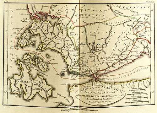
 Map of ancient Acarnania | |
| Location | Western Greece |
| Major cities | Stratos |
| Dialects | Doric |
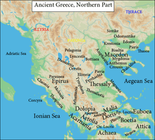
Acarnania (Greek: Ακαρνανία) is a region of west-central Greece that lies along the Ionian Sea, west of Aetolia, with the Achelous River for a boundary, and north of the gulf of Calydon, which is the entrance to the Gulf of Corinth. Today it forms the western part of the regional unit of Aetolia-Acarnania. The capital and principal city in ancient times was Stratos. The north[1] side of Acarnania of the Corinthian Gulf was considered part of the region of Epirus.
Acarnania's foundation in Greek mythology was traditionally ascribed to Acarnan, son of Alcmaeon.

History
Classical

In the 7th century BC,[2] Greek influence in the region became prominent when Corinth settled Anactorium, Sollium and Leucas, and Kefalonia settled Astacus. Settlements in Alyzeia, Coronta, Limnaia, Medion, Oeniadae, Palaerus, Phoitiai and Stratus are also mentioned by Thucydides, this latter city being the seat of a loose confederation of Acarnanian powers that was maintained until the late 1st century BC.
Because it is located strategically on the maritime route to Italy, Acarnania was involved in many wars. In the 5th century BC, the Corinthians were forced out of their Acarnanian settlements by Athens. The Acarnanian League came into existence as a loose federation of the Acarnanian cities. In the 4th century BC, c.390 BC, the cities of Acarnania surrendered to the Spartans under King Agesilaus, and continued to be Spartan allies until joining the Second Athenian Empire in 375 BC. The Acarnanians later sided with the Boeotians in their fight against Sparta, and with Athens against Philip II of Macedon at Chaeronea.
Acarnania thereafter came under Macedonian rule. In 314 BC, at the behest of the Macedonian king Cassander, the settlements of Acarnania lying near the Aetolian border were conglomerated into fewer, larger settlements. Still, border conflicts with the Aetolians were frequent, and led to Acarnania's territory being partitioned between Aetolia and Epirus, c.250 BC. After the fall of the king of Epirus, the Acarnanian territory that had been given to Epirus regained its independence, and Leucas became the capital of the region.
Acarnania allied itself with Philip V of Macedon against Rome in 200 BC, although it lost Leucas because of this, and the city of Thyrreion was appointed the new capital.
In the 1st century BC, Acarnania suffered greatly at the hands of pirates, and in Rome's civil wars. Afterwards, the towns and settlements of Acarnania fell under the rule of Nicopolis.
Byzantine
When the Byzantine Empire broke up (1204), Acarnania passed to the Despotate of Epirus and in 1348 it was conquered by Serbia. Then in 1480 it fell to the Ottoman Empire. Since 1832 it has been part of Greece.
Modern
Geography
Acarnania is composed of three main regions: 1) a rocky coastline, 2) a rugged strip of mountain range that follows the coastline, and 3) plains lying between these mountains and the Achelous River.
List of Acarnanians
- Carnus, seer of Apollo who established the cult of Apollo Carneus among the Dorians; see also Carnea.
- Amphilytus, seer of Peisistratos (Athens).
- Megistias, seer at the battle of Thermopylae.
- Lysimachus of Acarnania one of the tutors of Alexander the Great
- Philip of Acarnania, one of the physicians of Alexander the Great
- Machatas (sculptor)
- Aristomenes of Acarnania, guardian and regent of Ptolemy III Euergetes
- Alexander of Acarnania, general of Antiochus the Great
See also
- List of cities in ancient Acarnania.
- List of cities in Acarnania
- List of traditional Greek place names
References
- ↑ Adages III iv 1 to IV ii 100 by Desiderius Erasmus,2005,ISBN 0802036430,page 538,"Acarnania on the northern side of the Corinthian gulf was part of Epirus"
- ↑ Encyclopedia of ancient Greece
Sources
- Hornblower, Simon (1996). "Acarnania". The Oxford Classical Dictionary. Oxford: Oxford University Press. pp. 2–3.
-
 Chisholm, Hugh, ed. (1911). "Acarnania". Encyclopædia Britannica (11th ed.). Cambridge University Press.
Coordinates: 38°45′N 21°05′E / 38.750°N 21.083°E