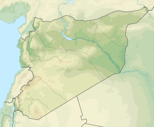
1157 Hama earthquake
 | |
| Date | 12 August 1157 |
|---|---|
| Magnitude | >7.0[1] |
| Epicenter | 35°06′N 36°30′E / 35.1°N 36.5°ECoordinates: 35°06′N 36°30′E / 35.1°N 36.5°E[1] |
| Areas affected | Syria (region) |
| Total damage | Extreme[2] |
| Max. intensity | VIII–IX |
| Casualties | 8,000[2] |
The 1157 Hama earthquake occurred on 12 August after a year of foreshocks. Its name was taken from the city of Hama, in west-central Syria (then under the Seljuk rule), where the most casualties were sustained.[1] In eastern Syria, near the Euphrates, the quake destroyed the predecessor of the citadel Al-Rahba, subsequently rebuilt on the same strategic site. The earthquake also affected Christian monasteries and churches in the vicinity of Jerusalem.
See also
References
- 1 2 3 Ambraseys, Nicholas N. (2004). "The 12th century seismic paroxysm in the Middle East: a historical perspective" (PDF). Annals of Geophysics. Istituto Nazionale Geofisica e Vulcanologia. 47 (2–3): 733, 738, 745, 750.
- 1 2 National Geophysical Data Center / World Data Service (NGDC/WDS), Significant Earthquake Database, National Geophysical Data Center, NOAA, doi:10.7289/V5TD9V7K
This article is issued from Wikipedia - version of the 7/6/2016. The text is available under the Creative Commons Attribution/Share Alike but additional terms may apply for the media files.